Mine Index Number: 0500
| Company Name:
|
Progressive Coal Mining Company
|
| Mine Name:
|
Progressive Mine
|
| Start Date:
|
1918
|
End Date:
|
1937
|
| Type of Mine:
|
Underground
|
| Total acres shown:
|
16
|
| Acres after map date:
|
|
General Area of mining acres shown:
|
|
|
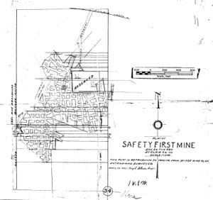
This is smaller than expected for the tonnage produced. Two general areas of mining have been added to the accompanying map, in the areas shown on the source map as inaccessible due to water in the mine.
|
Shaft, Slope, Drift or Tipple Location(s)
| Type
|
County
|
Township-Range
|
Section
|
Part Section
|
| Slope
|
St. Clair
|
1N 8W
|
34
|
SE NE NW
|
| Air shaft
|
St. Clair
|
1N 8W
|
34
|
SE NE NW
|
Geology
Geological Problems Reported
The source map shows areas in the south and southwest labeled “Caved”. Areas in the west and east were inaccessible due to water.
Production
| Company
|
Mine Name
|
Date
|
Production (tons)
|
| Breese Coal Company
|
Breese
|
1921-1928
|
38,655 Production not reported 1922 (Mines producing less than 10,000 tons were not included.)
|
|
|
|
|
|
|
|
| Total Production: 119,734
|
Production Notes
Coal Report production (if available)
Sources of Data
| Microfilm, document 351034
|
4-22-1937
|
1:2400
|
1:2400
|
Final
|
Annotated Bibliography (Data source - brief description of information)
| Coal Reports - Production, ownership, years of operation.
|
| Directory of Illinois Coal Mines (St. Clair County) - Mine names, mine index, ownership, years of operation.
|
| Mine notes (St. Clair County) - Slope location, mine type, seam, depth, thickness, abandonment date.
|
| Microfilm map, document 351034, reel 03134, frame 119 - Shaft and slope locations, mine outline, mining method, geologic problems.
|
Mine Notes
Mine Images
Microfilm: 351034
Map Date: 4-22-1937
Coal Co.: Progressive Mining Company
Mine Name: Progressive Mine
Full Res Download
Photographs


