3261: Difference between revisions
No edit summary |
No edit summary |
||
| Line 8: | Line 8: | ||
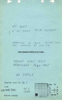
|Mine Name Header=Houston No. 1 Mine | |Mine Name Header=Houston No. 1 Mine | ||
|mine_type=Surface | |mine_type=Surface | ||
|mined-out-area=84 | |mined-out-area=84 This area includes some portions included under Houston No. 2 (mine index [[0888]]) and Johnson No. 1 Mine (mine index [[4581]]), and may include some un-mined areas (haulage, stockpile, etc.). | ||
|indicated= | |after_map=40 | ||
|indicated=Yes | |||
|county1=Saline | |county1=Saline | ||
|quad1=Carrier Mills | |quad1=Carrier Mills | ||
Latest revision as of 11:24, March 12, 2024
Mine Index Number: 3261
| Company Name: | Houston Coal Company | ||
|---|---|---|---|
| Mine Name: | Houston No. 1 Mine | ||
| Start Date: | 1955 | End Date: | May 1967 |
| Type of Mine: | Surface | ||
| Total acres shown: | 84 This area includes some portions included under Houston No. 2 (mine index 0888) and Johnson No. 1 Mine (mine index 4581), and may include some un-mined areas (haulage, stockpile, etc.). | ||
| Production Indicated Acres: | 40 | General Area of mining acres shown: | |
Shaft, Slope, Drift or Tipple Location(s)
| Type | County | Township-Range | Section | Part Section |
|---|
| Pit | Saline | 9S 5E | 27 | SW |
Geology
| Thickness (ft) | |||||
|---|---|---|---|---|---|
| Seam | Depth (ft) | Min | Max | Ave | Mining Method |
| Herrin | 25-30 | 4.67-4.83 | Surface |
Geological Problems Reported
Production
| Company | Mine Name | Date | Production (tons) |
| Houston Coal Company | Houston No. 1 | 1955-1967 | 266,443 |
| Total Production: 266,443 | |||
Production Notes
Coal Report production (if available)
Sources of Data
| Source Map | Map Date | Original Scale | Digitized Scale | Map Type |
| Coal Section files | Undated | 1:20124 | 1:20124 | Undated |
Annotated Bibliography (Data source - brief description of information)
| Coal Reports - Production, ownership, years of operation, depth, thickness. |
| Directory of Illinois Coal Mines (Saline County) - Mine names, mine index, ownership, years of operation. |
| Mine notes (Saline County) - Mine type, location, seam. |
| ISGS Coal Section files, strip mine updates - Mine outline. |
Mine Notes
Mine Images

Photographs