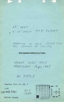
Mine Index Number: 3261
| Company Name:
|
Houston Coal Company
|
| Mine Name:
|
Houston No. 1 Mine
|
| Start Date:
|
1955
|
End Date:
|
May 1967
|
| Type of Mine:
|
Surface
|
| Total acres shown:
|
84 This area includes some portions included under Houston No. 2 (mine index 0888) and Johnson No. 1 Mine (mine index 4581), and may include some un-mined areas (haulage, stockpile, etc.).
|
| Production Indicated Acres:
|
40
|
General Area of mining acres shown:
|
|
|
|
Shaft, Slope, Drift or Tipple Location(s)
| Type
|
County
|
Township-Range
|
Section
|
Part Section
|
Geology
| Herrin
|
25-30
|
|
|
4.67-4.83
|
Surface
|
Geological Problems Reported
Production
| Company
|
Mine Name
|
Date
|
Production (tons)
|
Production Notes
Coal Report production (if available)
Sources of Data
| Coal Section files
|
Undated
|
1:20124
|
1:20124
|
Undated
|
Annotated Bibliography (Data source - brief description of information)
| Coal Reports - Production, ownership, years of operation, depth, thickness.
|
| Directory of Illinois Coal Mines (Saline County) - Mine names, mine index, ownership, years of operation.
|
| Mine notes (Saline County) - Mine type, location, seam.
|
| ISGS Coal Section files, strip mine updates - Mine outline.
|
Mine Notes
Mine Images
Photographs