Category:Nokomis-Quadrangle
County Coal Data
Mines that Appear in Nokomis-Quadrangle
*9998 & 9999 = Unknown dates
Unlocated Mines in Nokomis-Quadrangle
Mine that have known coal production but no known location
There are no known Unlocated mines in this county
Historical Mined Out Area Maps
WPA
These maps were constructed as part of the nationwide Works Projects Administration (WPA), generally between 1934 and 1937 with some later updates or revisions,
Disclaimer
Maps for some locations might have multiple versions/seams, please inspected these areas closely for differences.
Notes and corrections were made by ISGS staff.
These maps are reproductions from microfilm, they may be of poor quality with text difficult to read.
There are no Quade Maps for this county
Federal Land Bank of St. Louis, Preliminary Reports on Subsidence Investigations
Federal Land Bank of St. Louis, Preliminary Reports on Subsidence Investigations (refered by Coal Section Staff as "Quade Maps")
Mining engineers working for the Federal Land Bank of St. Louis mapped areas of subsidence due to coal mining in the early 1930s. These reports often include county maps of mine properties with mined-out areas including shaft locations, as well as subsidence areas.
Disclaimer
Maps for some locations might have multiple versions/seams, please inspected these areas closely for differences.
These maps are accompanied by a report, please download and inspect this document.
Notes and corrections were made by ISGS staff.
There are no Quade Maps for this county
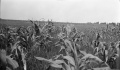
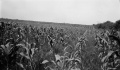
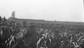
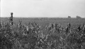
Photographs


Pages in category "Nokomis-Quadrangle"
The following 7 pages are in this category, out of 7 total.
Media in category "Nokomis-Quadrangle"
The following 20 files are in this category, out of 20 total.
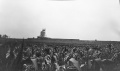 M-1000 Peabody 10 Nokomis sag corn field MI 194 8ft coal at 625ft.jpg 4,357 × 2,570; 1.32 MB
 M-1001 Peabody 10 Nokomis sag corn field MI 194 8ft coal at 625ft.jpg 4,381 × 2,567; 1.59 MB
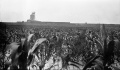
 M-809 Pond N of Witt Peabody 14.jpg 4,375 × 2,550; 1.04 MB
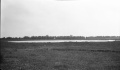
 M-995 Peabody 10 Nokomis sag corn field MI 194 8ft coal at 625ft.jpg 4,365 × 2,537; 1.09 MB
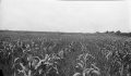
 M-996 Peabody 10 Nokomis sag corn field MI 194 8ft coal at 625ft.jpg 4,385 × 2,553; 1.19 MB
 M-997 Peabody 10 Nokomis sag corn field MI 194 8ft coal at 625ft.jpg 4,373 × 2,547; 1.21 MB
 M-998 Peabody 10 Nokomis sag corn field MI 194 8ft coal at 625ft.jpg 4,391 × 2,536; 1.54 MB
 M-999 Peabody 10 Nokomis Coop 17 fig 32 sag corn field MI 194 8ft coal at 625ft.jpg 4,370 × 2,536; 1.14 MB
 M0194 coalreport1905.pdf 633 × 977; 93 KB
 M0194 coalreport1906.pdf 1,579 × 1,285; 432 KB
 M0194 minenotes.pdf 737 × 1,193, 12 pages; 3.01 MB
 M0195 coalreport1914.pdf 1,750 × 1,320; 282 KB
 M0195 minenotes.pdf 737 × 1,193, 35 pages; 8.86 MB
 M0196 coalreport1896.pdf 1,587 × 1,202; 311 KB
 M0196 coalreport1910.pdf 583 × 943; 102 KB
 M0196 coalreport1917.pdf 602 × 991; 83 KB
 M0196 minenotes.pdf 733 × 1,193, 16 pages; 3.9 MB
 M0335 coalreport1906.pdf 1,579 × 1,285; 429 KB
 M0335 coalreport1907.pdf 587 × 966; 79 KB
 M0335 minenotes.pdf 737 × 1,193, 9 pages; 2.08 MB