Mine Index Number: 4541
| Company Name:
|
|
| Mine Name:
|
|
| Start Date:
|
{{{year-start}}}
|
End Date:
|
{{{year-end}}}
|
| Type of Mine:
|
Underground
|
| Total acres shown:
|
|
| Acres after map date:
|
|
General Area of mining acres shown:
|
|
|
|
"{{{year-start}}}" contains an extrinsic dash or other characters that are invalid for a date interpretation."{{{year-end}}}" contains an extrinsic dash or other characters that are invalid for a date interpretation.
Shaft, Slope, Drift or Tipple Location(s)
| Type
|
County
|
Township-Range
|
Section
|
Part Section
|
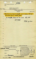
| Main shaft
|
Macoupin
|
9N 9W
|
2
|
SW NW NW
|
Geology
Geological Problems Reported
Production
| Company
|
Mine Name
|
Date
|
Production (tons)
|
Production Notes
Coal Report production (if available)
Sources of Data
Annotated Bibliography (Data source - brief description of information)
| Directory of Illinois Coal Mines (Macoupin County) - Mine location.
|
Mine Notes
Mine Images
Photographs