0871: Difference between revisions
No edit summary |
Alan.Myers (talk | contribs) No edit summary |
||
| (One intermediate revision by the same user not shown) | |||
| Line 8: | Line 8: | ||
|Mine Name Header=Hillsboro Mine (Consolidation No. 63 Mine) | |Mine Name Header=Hillsboro Mine (Consolidation No. 63 Mine) | ||
|mine_type=Underground | |mine_type=Underground | ||
|mined-out-area=4, | |mined-out-area=4,897 | ||
|indicated=No | |indicated=No | ||
|county1=Montgomery | |county1=Montgomery | ||
| Line 17: | Line 17: | ||
|year-start=September 1964 | |year-start=September 1964 | ||
|year-end=July 1983 | |year-end=July 1983 | ||
|Latitude=39. | |Latitude=39.05416984 | ||
|Longitude=-89. | |Longitude=-89.3935959 | ||
|Zoom=12 | |Zoom=12 | ||
}} | }} | ||
Latest revision as of 15:09, August 2, 2023
Mine Index Number: 0871
| Company Name: | Consolidation Coal Company | ||
|---|---|---|---|
| Mine Name: | Hillsboro Mine (Consolidation No. 63 Mine) | ||
| Start Date: | September 1964 | End Date: | July 1983 |
| Type of Mine: | Underground | ||
| Total acres shown: | 4,897 | ||
| Acres after map date: | General Area of mining acres shown: | ||
Shaft, Slope, Drift or Tipple Location(s)
| Type | County | Township-Range | Section | Part Section |
|---|
| Man shaft | Montgomery | 7N 3W | 14 | SW NE NW |
| Air shaft | Montgomery | 7N 2W | 18 | SE NE NE |
| Hoist and air shaft | Montgomery | 7N 3W | 14 | NE NW NW |
Geology
| Thickness (ft) | |||||
|---|---|---|---|---|---|
| Seam | Depth (ft) | Min | Max | Ave | Mining Method |
| Herrin | 500-510 | 5.83-7.17 | RPP |
Geological Problems Reported
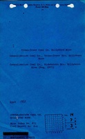
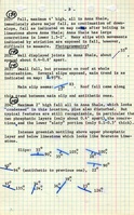
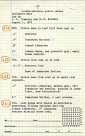
Roof problems were widespread, the sites characterized by slickensided fault planes that cut irregularly through the roof shales and claystones. Small clay dikes were also associated with this small-scale faulting. Floor heaving was slight, but had been a larger problem in the past.
Production
| Company | Mine Name | Date | Production (tons) |
| Truax-Traer Coal Company | Hillsboro | 1964-1970 | 5,605,812 |
| Consolidation Coal Company | Consolidation No. 63, Hillsboro | 1971-1983 | 21,173,542 |
| Total Production: 26,779,354 | |||
Production Notes
Coal Report production (if available)
Sources of Data
| Source Map | Map Date | Original Scale | Digitized Scale | Map Type |
| Company, Coal Section files | 2-1-1983 | 1:12000 | 1:2170 | FinalThe map date is before mine closure, but the Coal Section has been assured that the workings shown on the map are indeed final. The mined area shown on the accompanying map is the approximate size expected for the reported production. This suggests that the mine outline is complete. |
Annotated Bibliography (Data source - brief description of information)
| Coal Reports - Production, ownership, years of operation, mine type, depth, thickness. |
| Directory of Illinois Coal Mines (Montgomery County) - Mine names, mine index, ownership, years of operation. |
| Mine notes (Montgomery County) - Shaft location, seam, depth, thickness, geologic problems. |
| Company map, Coal Section files, 1983 Line Project - Shaft locations, mine outline, mining method. |
Mine Notes
Mine Images
![[[:Hillsboro|Hillsboro]]](https://go.illinois.edu/ILMImages/montgomery/thumbnails/Hillsboro_1983_th.jpg)
Photographs