1038: Difference between revisions
Kate.O'Brien (talk | contribs) No edit summary |
No edit summary |
||
| Line 69: | Line 69: | ||
|Date=2006-2009 | |Date=2006-2009 | ||
|Production=2,763,409 | |Production=2,763,409 | ||
|Sum=No | |||
}} | }} | ||
{{Production | {{Production | ||
| Line 75: | Line 76: | ||
|Date=2010- | |Date=2010- | ||
|Production=8,481,617 {{#info: The production shown is through 2015, the latest available Coal Report.|note}} | |Production=8,481,617 {{#info: The production shown is through 2015, the latest available Coal Report.|note}} | ||
|Sum=No | |||
}} | }} | ||
{{Production | {{Production | ||
|Production=------------ | |Production=------------ | ||
|Sum=No | |||
}} | }} | ||
{{Production | {{Production | ||
|Company=Total | |||
|Production=11,245,026 | |Production=11,245,026 | ||
|Sum=No | |||
}} | }} | ||
===Production Notes=== | ===Production Notes=== | ||
Revision as of 16:00, June 1, 2022
Mine Index Number: 1038
| Company Name: | Peabody Midwest Mining | ||
|---|---|---|---|
| Mine Name: | Wildcat Hills Underground Mine | ||
| Start Date: | 2006 | End Date: | Active |
| Type of Mine: | Underground | ||
| Total acres shown: | 1,429 | ||
| Acres after map date: | General Area of mining acres shown: | ||
Shaft, Slope, Drift or Tipple Location(s)
| Type | County | Township-Range | Section | Part Section |
|---|
| Main Drift | Saline | 9S 7E | 1 | SENWNW |
| Air drift | Saline | 9S 7E | 1 | SENWNW |
| Air drift | Saline | 9S 7E | 1 | SENWNW |
| Air drift | Saline | 9S 7E | 1 | SENWNW |
Geology
| Thickness (ft) | |||||
|---|---|---|---|---|---|
| Seam | Depth (ft) | Min | Max | Ave | Mining Method |
| Herrin | 110 | 4.5-5.0 | CRP |
Geological Problems Reported
(Geologic problems are not reported for active mines.)
Production
| Company | Mine Name | Date | Production (tons) |
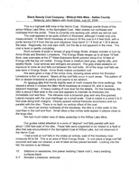
| Black Beauty Coal Company | Wildcat Hills Underground | 2006-2009 | 2,763,409 |
| Peabody Midwest Mining | Wildcat Hills Underground | 2010- | 8,481,617 The production shown is through 2015, the latest available Coal Report. |
| Total | 11,245,026 | ||
Production Notes
Coal Report production (if available)
Sources of Data
| Source Map | Map Date | Original Scale | Digitized Scale | Map Type |
| Company map, Coal Section files | 3-1-2009 | 1:3600 | 1:3600 | Not final |
| Company map, Coal Section Files | 12-31-2011 | 1:4800 | 1:4800 | Not final |
| Company, digital outline | 2014 | 1:24000 | 1:24000 | Not final |
Annotated Bibliography (Data source - brief description of information)
| Coal Reports - Production, ownership, years of operation. |
| Directory of Illinois Coal Mines (Saline County) - Mine names, mine index, ownership, years of operation. |
| Company map, Coal Section files (digital file) - Drift locations, mine outline, mining method. |
| Company map, Coal Section files (digital file) - Mine outline, mining method. |
| Company map, digital outline supplied to Illinois Department of Mines and Minerals - Mine outline. |
Mine Notes
Mine Images
![[[:Wildcat Hills Underground|Wildcat Hills Underground]]](https://wikiimage.isgs.illinois.edu/ilmines/saline/thumbnails/m1038_2019.jpg)
![[[:Wildcat Hills Underground|Wildcat Hills Underground]]](https://wikiimage.isgs.illinois.edu/ilmines/saline/thumbnails/m1038_2018.jpg)
Photographs