2678: Difference between revisions
Alan.Myers (talk | contribs) No edit summary |
Alan.Myers (talk | contribs) No edit summary Tag: Manual revert |
||
| (11 intermediate revisions by 3 users not shown) | |||
| Line 1: | Line 1: | ||
{{Sidebar Info Query}} | {{Sidebar Info Query}} | ||
{{Header | {{Header | ||
|checked=Checked OK | |||
|unlocated=No | |unlocated=No | ||
|shown_on_map=Yes | |shown_on_map=Yes | ||
| Line 8: | Line 9: | ||
|mine_type=Surface | |mine_type=Surface | ||
|mined-out-area=17{{#info: Production indicates approximately 5 acres were mined. The map may represent the area mined for clay as well the coal.|note}} | |mined-out-area=17{{#info: Production indicates approximately 5 acres were mined. The map may represent the area mined for clay as well the coal.|note}} | ||
|county1= | |indicated=No | ||
|quad1= | |county1=La Salle | ||
|quad1=La Salle | |||
|quad2=Starved Rock | |quad2=Starved Rock | ||
|year-start= | |city1=Streator | ||
|city3=Ranson | |||
|city2=Utica | |||
|year-start=1941 | |||
|year-end=1959 | |year-end=1959 | ||
|Latitude=41.3167023420001 | |||
|Longitude=-89.003291224 | |||
|Zoom=12 | |||
}} | }} | ||
==Shaft, Slope, Drift or Tipple Location(s)== | ==Shaft, Slope, Drift or Tipple Location(s)== | ||
| Line 22: | Line 30: | ||
|Town-Range=33N-2E | |Town-Range=33N-2E | ||
|Section=21 | |Section=21 | ||
|partsection=NW | |partsection=S 1/2 NW | ||
}} | }} | ||
==Geology== | ==Geology== | ||
| Line 43: | Line 51: | ||
|Date=1941-1947{{#info: Idle 1943-1947|note}} | |Date=1941-1947{{#info: Idle 1943-1947|note}} | ||
|Production=481 | |Production=481 | ||
|Sum=No | |||
}} | }} | ||
{{Production | {{Production | ||
| Line 49: | Line 58: | ||
|Date=1948-1948 | |Date=1948-1948 | ||
|Production=931 | |Production=931 | ||
|Sum=No | |||
}} | }} | ||
{{Production | {{Production | ||
| Line 55: | Line 65: | ||
|Date=1948-1949 | |Date=1948-1949 | ||
|Production=480 | |Production=480 | ||
|Sum=No | |||
}} | }} | ||
{{Production | {{Production | ||
|Company=Arthur Mart Clay | |Company=Arthur Mart Clay and Coal Company | ||
|Mine-Name=Mart | |Mine-Name=Mart | ||
|Date=1949-1958 | |Date=1949-1958 | ||
|Production=12,974 | |Production=12,974 | ||
|Sum=No | |||
}} | }} | ||
{{Production | {{Production | ||
| Line 67: | Line 79: | ||
|Date=1958-1958 | |Date=1958-1958 | ||
|Production=23 | |Production=23 | ||
|Sum=No | |||
}} | }} | ||
{{Production | {{Production | ||
| Line 73: | Line 86: | ||
|Date=1959-1959 | |Date=1959-1959 | ||
|Production=6,756 | |Production=6,756 | ||
|Sum=No | |||
| | |||
}} | }} | ||
{{Production | {{Production | ||
|Production=21,645 | |Production=21,645 | ||
|Sum=Yes | |||
}} | }} | ||
===Production Notes=== | ===Production Notes=== | ||
Latest revision as of 10:49, April 25, 2024
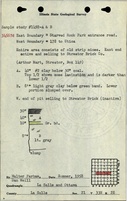
Mine Index Number: 2678
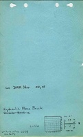
| Company Name: | Hydraulic Press Brick Company | ||
|---|---|---|---|
| Mine Name: | Hydraulic Press Brick Mine | ||
| Start Date: | 1941 | End Date: | 1959 |
| Type of Mine: | Surface | ||
| Total acres shown: | 17Production indicates approximately 5 acres were mined. The map may represent the area mined for clay as well the coal. | ||
| Acres after map date: | General Area of mining acres shown: | ||
Shaft, Slope, Drift or Tipple Location(s)
| Type | County | Township-Range | Section | Part Section |
|---|
| Pit | LaSalle | 33N-2E | 21 | S 1/2 NW |
Geology
| Thickness (ft) | |||||
|---|---|---|---|---|---|
| Seam | Depth (ft) | Min | Max | Ave | Mining Method |
| Colchester | 10-14 | 2.5 | Surface |
Geological Problems Reported
Production
| Company | Mine Name | Date | Production (tons) |
| Starved Rock Clay Company | Starved Rock | 1941-1947Idle 1943-1947 | 481 |
| Arthur Mart | Mart | 1948-1948 | 931 |
| Higgins Coal Company | Higgins | 1948-1949 | 480 |
| Arthur Mart Clay and Coal Company | Mart | 1949-1958 | 12,974 |
| Streator Brick Company | Streator | 1958-1958 | 23 |
| Hydraulic Press Brick Company | Hydraulic Press Brick | 1959-1959 | 6,756 |
| Total Production: 21,645 | |||
Production Notes
Coal Report production (if available)
Sources of Data
| Source Map | Map Date | Original Scale | Digitized Scale | Map Type |
| Microfilm, document 350389 | 3-28-1977 | 1:1200 | Unknown | Final |
| Company, 4103.L32 i5.3-1 | 2-24-1969 | 1:1200 | 1:1200 | Not final |
| Coal Section files, 6-85e | Undated | 1:62500 | 1:62500 | Secondary source |
Annotated Bibliography (Data source - brief description of information)
| Coal Reports - Production, ownership, years of operation, mining method. |
| Directory of Illinois Coal Mines (La Salle County) - Mine names, mine index, ownership, years of operation. |
| Mine notes (La Salle County) - Mine location, seam, depth, thickness. |
| Microfilm map, document 350389, reel 03132, frame 160 - Mine outline, mining method. |
| Company map, ISGS map library, 4103.L32 i5.3-1 - Mine outline (northern part). |
| Coal Section files, Colchester Coal overburden map, 6-85e - Mine outline (northern part). |
Mine Notes
Mine Images
Photographs