Mine Index Number: 0027
| Company Name:
|
Tazewell Coal Company
|
| Mine Name:
|
Tazewell Mine
|
| Start Date:
|
1900
|
End Date:
|
March 1924
|
| Type of Mine:
|
Underground
|
| Total acres shown:
|
596
|
| Acres after map date:
|
|
General Area of mining acres shown:
|
|
|
|
Shaft, Slope, Drift or Tipple Location(s)
| Type
|
County
|
Township-Range
|
Section
|
Part Section
|
| Shaft It is not clear on the source map which shaft is the hoist and which is the air shaft.
|
Tazewell
|
24N 4W
|
6
|
SW SW NW
|
| Shaft It is not clear on the source map which shaft is the hoist and which is the air shaft.
|
Tazewell
|
24N 5W
|
1
|
SE SE NE
|
Geology
| Springfield
|
162
|
4.3
|
4.8
|
4.6
|
RPP
|
Geological Problems Reported
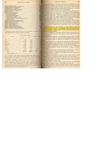
The limestone caprock was 1.5 to 2.0 feet above the coal, and was only solid locally, averaging 7 inches thick. Below the limestone was 1 foot of clod and 1 foot of massive black shale that stuck to the coal. Some concretions were present, fewer than other mines in the area. These concretions were fairly large, 5 by 24 inches. Thin pyrite lenses were common the lower part of the shale. Horsebacks were numerous, averaging 15 to 20 feet apart. Pyrite was heavier near the horsebacks, generally occurring as soft “brown sulphur”. Thin clay seams were also present in the coal. The floor was 2 feet of fire clay that heaved badly when exposed to air and more so when wet. The mine was generally dry.
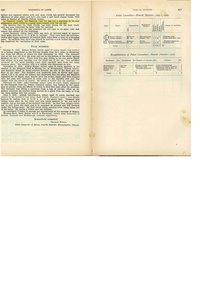
Production
| Company
|
Mine Name
|
Date
|
Production (tons)
|
|
|
|
|
|
| Total Production: 2,089,332
|
Production Notes
Coal Report production (if available)
Sources of Data
| Microfilm, document 352855
|
5-1-1924
|
1:2400
|
1:4303
|
Final
|
| Company, 4103.T3 i5.1-5
|
5-1-1924
|
1:2400
|
1:2400
|
Final
|
Annotated Bibliography (Data source - brief description of information)
| Coal Reports - Production, ownership, years of operation.
|
| Directory of Illinois Coal Mines (Tazewell County) - Mine names, mine index, ownership, years of operation.
|
| Mine notes (Tazewell County) - Mine type, shaft location, seam, depth, thickness, geologic problems.
|
| Microfilm map, document 352855, reel 03140, frames 472 & 473 - Mine outline, shaft locations, mining method.
|
| Company map, ISGS map library, 4103.T3 i5.1-5 - Mine outline (southern).
|
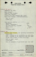
Mine Notes
Mine Images
 These files may not be true to scale and are not georgistered. These files may not be true to scale and are not georgistered.
|
Map Type:
|
Microfilm
|
| Map ID:
|
352855 03140, 472-473, 26x
|
| Company:
|
Tazewell Coal Company
|
| Mine Name:
|
|
| Caption:
|
|
| Map Date:
|
5-1-1924
|
| Map Status:
|
Final
|
| Image Credit:
|
|
| Note:
|
|
| More Info:
|
M0027
|
| Full Res Download:These files are true to scale and most are georegistered for gis software. These files may be a very large (>1GB) download!
|
https://wikiimage.isgs.illinois.edu/ilmines/tazewell/m0027.zip
|
Photographs