Mine Index Number: 0034
| Company Name:
|
Union Fuel Coal Company
|
| Mine Name:
|
Union No. 4 Mine
|
| Start Date:
|
1892
|
End Date:
|
February 1923
|
| Type of Mine:
|
Underground
|
| Total acres shown:
|
591
|
| Acres after map date:
|
31
|
General Area of mining acres shown:
|
|
|
|
Shaft, Slope, Drift or Tipple Location(s)
| Type
|
County
|
Township-Range
|
Section
|
Part Section
|
| Main shaft
|
Menard
|
18N 6W
|
36
|
SE SW NW
|
| Air shaft
|
Menard
|
18N 6W
|
36
|
SE SW NW
|
| Air shaft
|
Menard
|
18N 6W
|
35
|
SE SW NW
|
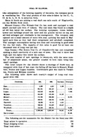
Geology
| Springfield
|
203
|
5.6
|
6.1
|
6.0
|
RPP
|
Geological Problems Reported
Lenticular pods of black shale up to 3 feet thick made up the roof over much of the mine. In some cases, about 5 feet of limestone was over the black shale. “Soapstone”, a very clay-rich shale, was the rock above the limestone. When the limestone came down, the soapstone would also fail. One fall extended 35 feet upwards. Numerous clay veins were present in the coal, some 2 feet wide. At least one clay vein was associated with a slip where the coal was shattered for 1 foot on either side. A small fault with 1.5 feet offset was found ¼ mile east of the shaft. Pyrite lenses were present along bedding planes. The underclay floor was 7 feet of fairly soft clay, with a firmer clay below that contained boulders. The upper part heaved, especially the top 1.5 feet. The mine map shows that old works of the Athens-Dawson Mine (mine index 2939) were encountered in the southern part of the eastern extensions of this mine.
Production
| Company
|
Mine Name
|
Date
|
Production (tons)
|
|
|
|
|
|
| Total Production: 2,247,302
|
Production Notes
Coal Report production (if available)
Sources of Data
| Microfilm, document 352214
|
2-4-1921
|
1:2400
|
1:4800
|
Not final
|
| Company, PB_360
|
2-16-2913
|
1:2400
|
1:2400
|
Final
|
Annotated Bibliography (Data source - brief description of information)
| Coal Reports - Production, ownership, years of operation.
|
| Directory of Illinois Coal Mines (Menard County) - Mine names, mine index, ownership, years of operation.
|
| Mine notes (Menard County) - Mine type, shaft location, seam, depth, thickness, geologic problems.
|
| Microfilm map, document 352214, reel 03138, frames 269-272 - Shaft locations, mine outline, location of old works.
|
| Company map, state archive, PB_360 - Mine outline (eastern & southeastern).
|
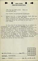
Mine Notes
Mine Images
Microfilm: 352214
Map Date: 2-4-1921
Coal Co.: Union Fuel Company
Mine Name: Union No. 4 Mine
Full Res Download
Company Map: PB_360
Map Date: 2-16-1923
Coal Co.: Union Fuel Company
Mine Name: Union No. 4 Mine
Image Credit: Illinois Department of Natural Resources - Office of Mines and Minerals
Full Res Download
Photographs