Mine Index Number: 0051
| Company Name:
|
Peabody Coal Company
|
| Mine Name:
|
Peabody No. 19 Mine
|
| Start Date:
|
1904
|
End Date:
|
June 1936
|
| Type of Mine:
|
Underground
|
| Total acres shown:
|
1,915
|
| Acres after map date:
|
|
General Area of mining acres shown:
|
|
|
|
Shaft, Slope, Drift or Tipple Location(s)
| Type
|
County
|
Township-Range
|
Section
|
Part Section
|
| Main shaft
|
Franklin
|
7S 3E
|
18
|
Center SE SW
|
| Air shaft
|
Franklin
|
7S 3E
|
18
|
1100 FSL, 2050 FWL
|
Geology
| Herrin
|
500
|
9.0
|
11.0
|
10.0
|
RPP
|
Geological Problems Reported
The mine had gas problems; eight people were killed in four explosions between 1907 and 1925. One or two small faults were reported. The shale roof was soft and projected into the coal in several places as rolls. Generally 3 feet of top coal was left to protect the roof. Sulfur balls were scattered through the coal.
Production
| Company
|
Mine Name
|
Date
|
Production (tons)
|
|
|
|
|
|
| Total Production: 12,132,479
|
Production Notes
Coal Report production (if available)
Sources of Data
| Microfilm, document 351419
|
7-1936
|
1:2400
|
1:2813
|
Final
|
| Microfilm, document 351453
|
7-1-1960
|
1:2400
|
1:5296
|
Secondary source
|
Annotated Bibliography (Data source - brief description of information)
| Coal Reports - Production, ownership, years of operation, geologic problems.
|
| Directory of Illinois Coal Mines (Franklin County) - Mine names, mine index, ownership, years of operation.
|
| Mine notes (Franklin County) - Mine type, shaft locations, seam, depth, thickness, geologic problems.
|
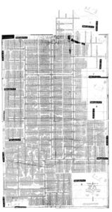
| Microfilm map, document 351419, reel 03136, frames 54-62 - Shaft locations, mine outline, mining method.
|
| Microfilm map, document 351453, reel 03136, frames 160-171, map of Orient No. 2 Mine (mine index 366) - Mine outline (southwestern extension).
|
Mine Notes
Mine Images
Microfilm: 351419
Map Date: 7-1936
Coal Co.: Peabody Coal Company
Mine Name: Peabody No. 19 Mine
Full Res Download
![[[:Orient No. 2|Orient No. 2]]](https://go.illinois.edu/ILMImages/franklin/thumbnails/m0366_th.jpg) These files may not be true to scale and are not georgistered. These files may not be true to scale and are not georgistered.
|
Map Type:
|
Microfilm
|
| Map ID:
|
351453
|
| Company:
|
Orient Number Two Coal Company
|
| Mine Name:
|
Orient No. 2
|
| Caption:
|
|
| Map Date:
|
7-1-1960
|
| Map Status:
|
Not final
|
| Image Credit:
|
|
| Note:
|
|
| More Info:
|
M0366
|
| Full Res Download:These files are true to scale and most are georegistered for gis software. These files may be a very large (>1GB) download!
|
https://wikiimage.isgs.illinois.edu/ilmines/franklin/m0366.zip
|
Photographs


![[[:Orient No. 2|Orient No. 2]]](https://go.illinois.edu/ILMImages/franklin/thumbnails/m0366_th.jpg)