Mine Index Number: 0075
| Company Name:
|
Peabody Coal Company
|
| Mine Name:
|
Peabody No. 54 Mine
|
| Start Date:
|
1904
|
End Date:
|
December 1926
|
| Type of Mine:
|
Underground
|
| Total acres shown:
|
1,120
|
| Acres after map date:
|
|
General Area of mining acres shown:
|
|
|
|
Shaft, Slope, Drift or Tipple Location(s)
| Type
|
County
|
Township-Range
|
Section
|
Part Section
|
| Main shaft (8.5 ft x 14 ft)
|
Sangamon
|
13N 6W
|
15
|
SE NE SW
|
| Air shaft (8.5 ft x 15.8 ft)
|
Sangamon
|
13N 6W
|
15
|
SE NE SW
|
Geology
| Herrin
|
301-308
|
4.5
|
11.0
|
7.0-7.5
|
RPP
|
Geological Problems Reported
An overlying sandstone bed cut into the coal in some areas of the mine, but the roof over most of the mine was black shale. Top coal was left to support the roof. Small rolls and slips were also present in the coal. Pyrite balls were found in masses in the coal. The fireclay floor heaved in wet areas of the mine.
Production
| Company
|
Mine Name
|
Date
|
Production (tons)
|
|
|
|
|
|
| Total Production: 6,383,564
|
Production Notes
Coal Report production (if available)
Sources of Data
| State archive, IL_359_03
|
9-1-1927
|
1:2400
|
1:2400
|
Final
|
Annotated Bibliography (Data source - brief description of information)
| Coal Reports - Production, ownership, years of operation.
|
| Directory of Illinois Coal Mines (Sangamon County) - Mine names, mine index, ownership, years of operation.
|
| Mine notes (Sangamon County) - Mine type, shaft location, seam, depth, thickness, geologic problems.
|
| State archive, IL_359_03 - Shaft locations, mine outline, mining method.
|
Mine Notes
Mine Images
![[[:Peabody No. 54|Peabody No. 54]]](https://go.illinois.edu/ILMImages/sangamon/thumbnails/m0075_IL_359_03_th.jpg) These files may not be true to scale and are not georgistered. These files may not be true to scale and are not georgistered.
|
Map Type:
|
State Archive
|
| Map ID:
|
IL_359_03
|
| Company:
|
Peabody Coal Company
|
| Mine Name:
|
Peabody No. 54
|
| Caption:
|
|
| Map Date:
|
01-01-1931
|
| Map Status:
|
Final
|
| Image Credit:
|
|
| Note:
|
|
| More Info:
|
M0075 IL 359 03
|
| Full Res Download:These files are true to scale and most are georegistered for gis software. These files may be a very large (>1GB) download!
|
https://go.illinois.edu/ILMImages/sangamon/m0075 IL 359 03.zip
|
Photographs
Additional Notes
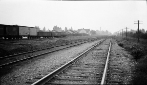
Caption: IL Central looking North from Madison shaft Divernon--sag in tracks and fill on rightt tracks
Credit: Illinois State Geological Survey
Library No.: M-1047


![[[:Peabody No. 54|Peabody No. 54]]](https://go.illinois.edu/ILMImages/sangamon/thumbnails/m0075_IL_359_03_th.jpg)
