Mine Index Number: 0120
| Company Name:
|
Panther Creek Mines, Inc.
|
| Mine Name:
|
Panther Creek No. 3 Mine
|
| Start Date:
|
1906
|
End Date:
|
February 1931
|
| Type of Mine:
|
Underground
|
| Total acres shown:
|
800
|
| Acres after map date:
|
|
General Area of mining acres shown:
|
|
|
|
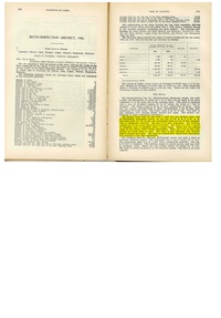
Shaft, Slope, Drift or Tipple Location(s)
| Type
|
County
|
Township-Range
|
Section
|
Part Section
|
| Main shaft 8 ft x 14 ft
|
Sangamon
|
16N 5W
|
19
|
NW NE SE
|
| Air shaft 8 ft x 13 ft
|
Sangamon
|
16N 5W
|
19
|
NE NE SE
|
Geology
| Springfield
|
171
|
5.0
|
6.0
|
5.5
|
MRP
|
Geological Problems Reported
Clay “horsebacks” were reported, and there were many concretions in the black shale roof. The roof had some local areas that were difficult to support, which occurred where there were slips in the shale.
Production
| Company
|
Mine Name
|
Date
|
Production (tons)
|
|
|
|
|
|
| Total Production: 3,471,517
|
Production Notes
Coal Report production (if available)
Sources of Data
| State Archive, IL_380_09
|
3-31-1947
|
1:2400
|
1:5700
|
Final
|
| State Archive, IL_60
|
2-24-1930
|
1:2400
|
1:4800
|
Not final
|
Annotated Bibliography (Data source - brief description of information)
| Coal Reports - Production, ownership, years of operation.
|
| Directory of Illinois Coal Mines (Sangamon County) - Mine names, mine index, ownership, years of operation.
|
| Mine notes (Sangamon County) - Mine type, shaft location, seam, depth, thickness, geologic problems.
|
| State Archive, IL_380_09 (Panther Creek No. 4) - Mine outline.
|
| State Archive, IL_60 - Shaft locations, mine outline, mining method.
|
Mine Notes
Mine Images
Photographs
Additional Notes
![[[:Panther Creek No. 4|Panther Creek No. 4]]](https://go.illinois.edu/ILMImages/sangamon/thumbnails/m0618_IL_380_09_geo_th.jpg)
![[[:Panther Creek No. 3|Panther Creek No. 3]]](https://go.illinois.edu/ILMImages/sangamon/thumbnails/m0120_IL_60_geo_th.jpg)