Mine Index Number: 0129
| Company Name:
|
Peabody Coal Company
|
| Mine Name:
|
Peabody No. 44 Mine
|
| Start Date:
|
1917
|
End Date:
|
1929
|
| Type of Mine:
|
Underground
|
| Total acres shown:
|
174
|
| Acres after map date:
|
|
General Area of mining acres shown:
|
|
|
|
Shaft, Slope, Drift or Tipple Location(s)
| Type
|
County
|
Township-Range
|
Section
|
Part Section
|
| Main shaft (12.5x4)
|
Saline
|
9S 5E
|
15
|
SE NW NE
|
| Air shaft (12.5x26.3)
|
Saline
|
9S 5E
|
15
|
NE NW NE
|
Geology
| Springfield
|
275 (260-285)
|
4.67
|
7.25
|
4.42-6.25
|
RPP
|
Geological Problems Reported
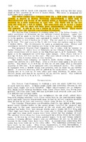
East-west trending faults were present in the northern and southern parts of the mine. The noted displacements on these faults were generally 1 to 5 feet, ranging up to 15 feet. They disrupted the mining pattern in the northwestern part of the mine. Northwest-southeast trending faults appear to have caused more difficulties with mining, especially one near the air shaft having 27 feet of displacement. The black shale roof was generally good. Some pyrite lenses were found in the seam. Rolls were noted on the source map in the eastern and northwestern parts of the mine.
Production
| Company
|
Mine Name
|
Date
|
Production (tons)
|
|
|
|
|
|
| Total Production: 1,109,621
|
Production Notes
Coal Report production (if available)
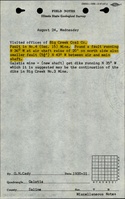
Sources of Data
| Company, 4103.S32 i5.1-13
|
6-18-1929
|
1:1200
|
1:1200
|
Final
|
Annotated Bibliography (Data source - brief description of information)
| Coal Reports - Production, ownership, years of operation, shaft sizes, thickness.
|
| Directory of Illinois Coal Mines (Saline County) - Mine names, mine index, ownership, years of operation.
|
| Mine notes (Saline County) - Mine type, shaft location, seam, depth, thickness, geologic problems.
|
| ISGS field notes (Saline County) - Geologic problems.
|
| Company map, ISGS map library, 4103.S32 i5.1-13 - Shaft locations, mine outline, mine type, geologic problems.
|
Mine Notes
Mine Images
![[[:Peabody No. 44|Peabody No. 44]]](https://wikiimage.isgs.illinois.edu/ilmines/saline/thumbnails/m0129_th.jpg) These files may not be true to scale and are not georgistered. These files may not be true to scale and are not georgistered.
|
Map Type:
|
Company
|
| Map ID:
|
4103.s32 i5.1-13
|
| Company:
|
Peabody Coal Company
|
| Mine Name:
|
Peabody No. 44
|
| Caption:
|
|
| Map Date:
|
6/18/1929
|
| Map Status:
|
Final
|
| Image Credit:
|
|
| Note:
|
|
| More Info:
|
M0129.jpg
|
| Full Res Download:These files are true to scale and most are georegistered for gis software. These files may be a very large (>1GB) download!
|
https://wikiimage.isgs.illinois.edu/ilmines/saline/m0129.zip
|
Photographs