Mine Index Number: 0211
| Company Name:
|
E. S. Gray
|
| Mine Name:
|
Gray No. 4 Mine and Gray Surface Mine
|
| Start Date:
|
1903
|
End Date:
|
1913
|
| Type of Mine:
|
Underground and Surface
|
| Total acres shown:
|
None
|
| Production Indicated Acres:
|
95 underground and 3 surface
|
General Area of mining acres shown:
|
|
|
|
Shaft, Slope, Drift or Tipple Location(s)
| Type
|
County
|
Township-Range
|
Section
|
Part Section
|
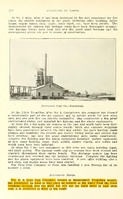
| Main shaft The underground mine was abandoned due to water from the river breaking through into the mine; the main entry was used to haul surface-mined coal to the tipple. (1910 Coal Report, p. 328)
|
Vermilion
|
19N 12W
|
17
|
NE NE NE
|
| Pit and tipple The underground mine was abandoned due to water from the river breaking through into the mine; the main entry was used to haul surface-mined coal to the tipple. (1910 Coal Report, p. 328)
|
Vermilion
|
19N 12W
|
16
|
NW NW NW
|
Geology
Geological Problems Reported
Production
| Company
|
Mine Name
|
Date
|
Production (tons)
|
|
|
|
|
|
| Total Production: 480,747
|
Production Notes
Coal Report production (if available)
Sources of Data
| ISGS map library, 4103.V4 i5.1-9
|
8-30-1939
|
1:4800
|
1:4800
|
Secondary source
|
Annotated Bibliography (Data source - brief description of information)
| Coal Reports - Production, ownership, years of operation, depth, thickness, mining method.
|
| Directory of Illinois Coal Mines (Vermilion County) - Mine names, mine index, ownership, years of operation.
|
| Mine notes (Vermilion County) - Mine type, shaft location, seam.
|
| ISGS map library, 4103.V4 i5.1-9, map of Morgan Coal Company (mine index 663) - Shaft location.
|
Mine Notes
Mine Images
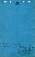
Company: 4103.V4 i5.1-9
Map Date: 8-30-1939
Coal Co.: F. C. Morgan Coal Company
Mine Name: Old Vermilion Mine
Full Res Download
Photographs