Mine Index Number: 0221
| Company Name:
|
Springside Coal Company
|
| Mine Name:
|
Springside No. 3 Mine
|
| Start Date:
|
1889
|
End Date:
|
1924
|
| Type of Mine:
|
Underground
|
| Total acres shown:
|
724
|
| Acres after map date:
|
20
|
General Area of mining acres shown:
|
|
|
|
Shaft, Slope, Drift or Tipple Location(s)
| Type
|
County
|
Township-Range
|
Section
|
Part Section
|
| Main shaft This mine was connected underground to the Penwell Mine (mine index 371) in 1893, for mutual escapement.
|
Christian
|
11N 1E
|
15
|
NW NW SE
|
| Air shaft
|
Christian
|
11N 1E
|
15
|
NW NW SE
|
Geology
| Herrin
|
720
|
6.0
|
12.0
|
7.5
|
RPP
|
Geological Problems Reported
Some gas was present; a gas explosion killed the company mine examiner in 1921. The immediate roof was 6 inches to 16 feet of black shale that had many slips. These slips made the roof unstable; it came down readily and required heavy timbering. Top coal may have been left to support the roof until the room was ready for abandonment, as evidenced by a fall of top coal causing a fatality in 1917. Above the black shale was a dark gray shale. A limestone cap rock was above the shale. Pyrite in lenses and bands was present throughout the coal, both laterally and vertically.
Production
| Company
|
Mine Name
|
Date
|
Production (tons)
|
|
|
|
|
|
| Total Production: 4,097,795
|
Production Notes
Coal Report production (if available)
Sources of Data
| Company, R4103.C4 i5.1-1
|
5-1923
|
1:2400
|
1:2400
|
Not final
|
Annotated Bibliography (Data source - brief description of information)
| Coal Reports - Production, ownership, years of operation, geologic problems.
|
| Directory of Illinois Coal Mines (Christian County) - Mine names, mine index, ownership, years of operation.
|
| Mine notes (Christian County) - Mine type, shaft location, seam, depth, thickness, geologic problems.
|
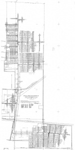
| Company map, ISGS map library R4103.C4 i5.1-1 - Shaft locations, mine outline, mining method.
|
Mine Notes
Mine Images
Company: R4103.C4 i5.1-1
Map Date: 5-1923
Coal Co.: Springside Coal Company
Mine Name: Springside No. 3 Mine
Image Credit: Illinois State Geological Survey
Full Res Download
Photographs
Additional Notes

