Mine Index Number: 0309
| Company Name:
|
Cantrall Coal Company
|
| Mine Name:
|
Cantrall Mine
|
| Start Date:
|
1890
|
End Date:
|
1924
|
| Type of Mine:
|
Underground
|
| Total acres shown:
|
534
|
| Acres after map date:
|
52
|
General Area of mining acres shown:
|
|
|
|
Shaft, Slope, Drift or Tipple Location(s)
| Type
|
County
|
Township-Range
|
Section
|
Part Section
|
| Main shaft
|
Sangamon
|
17N 5W
|
8
|
2680 FSL, 2280 FWL
|
| Air shaft
|
Sangamon
|
17N 5W
|
8
|
2740 FSL, 2740 FWL
|
Geology
Geological Problems Reported
The roof was a black shale that ranged from 1.5 to 4.0 ft thick. Concretions were common in the black shale. Horsebacks were seen. Pyrite nodules were said to be more numerous near the horsebacks. The floor was 5 to 10 ft of fire clay that heaved when wet.
Production
| Company
|
Mine Name
|
Date
|
Production (tons)
|
|
|
|
|
|
| Total Production: 2,687,961
|
Production Notes
Coal Report production (if available)
Sources of Data
| Microfilm, document 351196
|
8-1918
|
1:2400
|
1:4303
|
Not final
|
Annotated Bibliography (Data source - brief description of information)
| Coal Reports - Production, ownership, years of operation.
|
| Directory of Illinois Coal Mines (Sangamon County) - Mine names, mine index, ownership, years of operation.
|
| Mine notes (Sangamon County) - Mine type, shaft locations, seam, depth, thickness, geologic problems.
|
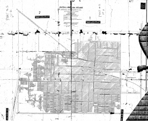
| Microfilm map, document 351196, reel 03134, frames 360-361 - Shaft locations, mine outline, mining method.
|
Mine Notes
Mine Images
Microfilm: 351196
Map Date: 8-1918
Coal Co.: Cantrall Coal Co.
Mine Name: Cantrall Mine
Photographs
Additional Notes


