Mine Index Number: 0311
| Company Name:
|
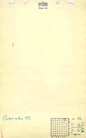
Coronado Coal Mining Company
|
| Mine Name:
|
Coronado Mine
|
| Start Date:
|
1905
|
End Date:
|
1911
|
| Type of Mine:
|
Underground
|
| Total acres shown:
|
20
|
| Acres after map date:
|
|
General Area of mining acres shown:
|
62
|
|
|
Shaft, Slope, Drift or Tipple Location(s)
| Type
|
County
|
Township-Range
|
Section
|
Part Section
|
| Main shaft 7 ft x 14 ft
|
Sangamon
|
16N 3W
|
26
|
NW NE NE
|
| Air shaft 7 ft x 14 ft
|
Sangamon
|
16N 3W
|
26
|
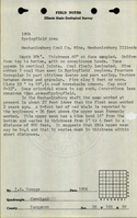
NW NE NE Mine notes state that the air shaft was 346 feet north of the main shaft. The air shaft is not shown on the accompanying map, because the source map used for the shaft and mine outline is quuite generalized and does not warrant extrapolations.
|
Geology
Geological Problems Reported
The roof consisted of clod that was not always present but could be up to 4 feet thick, and black shale up to 6 inches thick. Two pyrite-rich layers were present in the coal.
Production
| Company
|
Mine Name
|
Date
|
Production (tons)
|
Production Notes
Coal Report production (if available)
Sources of Data
| Federal Land Bank Report
|
2-1934
|
1:158400
|
1:158400
|
Secondary source
|
Annotated Bibliography (Data source - brief description of information)
| Coal Reports - Production, ownership, years of operation, shaft sizes, mining method.
|
| Directory of Illinois Coal Mines (Sangamon County) - Mine names, mine index, ownership, years of operation.
|
| Mine notes (Sangamon County) - Mine type, shaft location, seam, depth, thickness, geologic problems.
|
| Federal Land Bank Report (Sangamon County) - Shaft location, mine outline.
|
Mine Notes
Mine Images
Federal Land Bank Report: Sangamon County
Map Date: 1934
Coal Co.: Illinois Collieries
Mine Name: Illinois Collieries No. 3 Mine
Full Res Download
Photographs
Additional Notes