Mine Index Number: 0320
| Company Name:
|
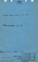
Bois Coal Company
|
| Mine Name:
|
Kuhn Mine
|
| Start Date:
|
1865
|
End Date:
|
February 1961
|
| Type of Mine:
|
Underground
|
| Total acres shown:
|
304
|
| Acres after map date:
|
|
General Area of mining acres shown:
|
|
|
|
Shaft, Slope, Drift or Tipple Location(s)
| Type
|
County
|
Township-Range
|
Section
|
Part Section
|
| Main shaft (5.5 x 13 ft)
|
Washington
|
3S 1W
|
33
|
NW NW NE
|
| Air and escape shaft
|
Washington
|
3S 1W
|
33
|
SE NW NE
|
Geology
| Herrin
|
294
|
5.5
|
6.5
|
6.0
|
MRP
|
Geological Problems Reported
The immediate roof was commonly 2 to 3 feet of black shale under limestone. A limey shale "rock" was locally present between the black shale and the coal. The "rock" was 1.5 to 2 feet thick and 25 to 100 feet across, and contained concretions of lime carbonate. The coal thinned under these wedges, the thinning about the same as the thickness of the wedge. The "rock" wedges were the major problem in the mine, with good roof otherwise and a uniform coal seam. Pyrite was present in lenses and in some vertical fractures (not persistent or numerous), and not easily removed from the coal at the face. A ½ inch thick clay band was common about 3 feet below the top of the coal. The blue band was 1 to 2 inches thick, and usually 4 inches above the bottom of the seam. The mine was generally dry, but the oldest entries were entirely closed off due to heaving. The bench of coal under the blue band was not mined in some parts of the mine, perhaps to keep the heaving to a minimum. The mine was closed due to a serious cave-in at the shaft. This was the oldest operating mine through modern times.
Production
| Company
|
Mine Name
|
Date
|
Production (tons)
|
| G. W. Brown
|
Brown
|
1865-1884 Production and years of operation before 1882 are not known. The 1883 Coal Report indicated 10 acres weremined. A 1956 newspaper article indicated that the mine opened in 1865.
|
56,000
|
|
|
|
|
|
|
|
| Total Production: 1,260,828
|
Production Notes
Coal Report production (if available)
Sources of Data
| Microfilm, document 353035
|
3-10-1961
|
1:2400
|
1:4138
|
Final
|
Annotated Bibliography (Data source - brief description of information)
| Coal Reports - Production, ownership, years of operation.
|
| Directory of Illinois Coal Mines (Washington County) - Mine names, mine index, ownership, years of operation.
|
| Mine notes (Washington County) - Mine type, shaft size & location, seam, depth, thickness, geologic problems.
|
| Brinkman, Grover, 1968 - Ownership (1910-1921), geologic problems.
|
| Microfilm map, document 353035, reel 03141, frame 217 - Shaft locations, mine outline, mining method.
|
Mine Notes
Mine Images
Photographs