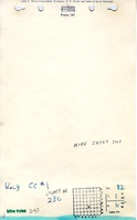
Mine Index Number: 0340
| Company Name:
|
Kolb Coal Company
|
| Mine Name:
|
Mascoutah Mine
|
| Start Date:
|
1895
|
End Date:
|
1930
|
| Type of Mine:
|
Underground
|
| Total acres shown:
|
978
|
| Acres after map date:
|
|
General Area of mining acres shown:
|
|
|
The boundaries between Home Mine (mine index 3485) and Mascoutah No. 1 Mine (mine index 0340) could not be distinguished. The acreage reported is the total for these two mines.
|
Shaft, Slope, Drift or Tipple Location(s)
| Type
|
County
|
Township-Range
|
Section
|
Part Section
|
| Main shaft (6' x 12')
|
St. Clair
|
1N 6W
|
32
|
SW NW SE
|
| Air shaft
|
St. Clair
|
1N 6W
|
32
|
SW NW SE
|
Geology
| Herrin
|
160
|
6.0
|
8.0
|
7.0
|
MRP
|
Geological Problems Reported
The roof contains concretions. The lower bench of the coal (below the blue band) has a number or sulphur balls.
Production
| Company
|
Mine Name
|
Date
|
Production (tons)
|
|
|
|
|
|
| Total Production: 3,096,758
|
Production Notes
Coal Report production (if available)
Sources of Data
| Company, 4103.S31 i5.1-6
|
10-9-1942
|
1:2400
|
1:2400
|
Final
|
Annotated Bibliography (Data source - brief description of information)
| Coal Reports - Production, ownership, years of operation.
|
| Directory of Illinois Coal Mines (St. Clair County) - Mine names, mine index, ownership, years of operation.
|
| Mine notes (St. Clair County) - Mine type, shaft size, seam, depth, thickness, geologic problems.
|
| Company map, ISGS map library, 4103.S31 i5.1-6 - Shaft locations, mine outline, mining method.
|
Mine Notes
Mine Images
Company: 4103.S31 i5.1-6
Map Date: 10-9-1942
Coal Co.: Kolb Coal Company
Mine Name: Kolb No. 1 and No. 2 Mines
Full Res Download
Photographs