Mine Index Number: 3485
| Company Name:
|
Home Coal Company
|
| Mine Name:
|
Home Mine
|
| Start Date:
|
1912
|
End Date:
|
1941
|
| Type of Mine:
|
Underground
|
| Total acres shown:
|
978
|
| Acres after map date:
|
|
General Area of mining acres shown:
|
|
|
The boundaries between Home Mine and Mascoutah No. 1 Mine (mine index 0340) could not be distinguished. The acreage reported is the total for these two mines.
|
Shaft, Slope, Drift or Tipple Location(s)
| Type
|
County
|
Township-Range
|
Section
|
Part Section
|
| Main shaft (7'x16')
|
St. Clair
|
1N 6W
|
32
|
SW NW NE
|
| Air shaft
|
St. Clair
|
1N 6W
|
32
|
SW NW NE
|
Geology
| Herrin
|
160-185
|
6.5
|
9.0
|
7.67
|
MRP
|
Geological Problems Reported
The roof is limestone over more than 50% of the mine. In these areas, there is a clod between the coal and the roof that tends to stick to the coal. Cracks are present in some places, and there is generally some movement where the cracks are present - usually an inch or two, but rarely as much as a foot. The coal under the larger cracks have clay-filled cracks similar to the horsebacks of the Springfield Coal. Where black shale forms the roof, concretions are common, generally 1 to 3 feet in diameter. The black shale is difficult to keep up. Pyrite occurs in sheets between the benches, especially in and about 5 inches above the blue band.
Production
| Company
|
Mine Name
|
Date
|
Production (tons)
|
|
|
|
|
|
| Total Production: 2,527,015
|
Production Notes
Coal Report production (if available)
Sources of Data
| Company, 4103.S31 i5.1-6
|
10-9-1942
|
1:2400
|
1:2400
|
Final
|
Annotated Bibliography (Data source - brief description of information)
| Coal Reports - Production, ownership, years of operation.
|
| Directory of Illinois Coal Mines (St. Clair County) - Mine names, mine index, ownership, years of operation.
|
| Mine notes (St. Clair County) - Mine type, shaft location and size, seam, depth, thickness, geologic problems.
|
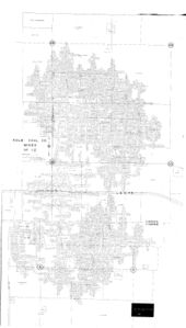
| Company map, ISGS map library, 4103.S31 i5.1-6 - Shaft locations, mine outline, mining method.
|
| Federal Land Bank Report - Depth, thickness.
|
Mine Notes
Mine Images
Company: 4103.S31 i5.1-6
Map Date: 10-9-1942
Coal Co.: Kolb Coal Company
Mine Name: Kolb No. 1 and No. 2 Mines
Full Res Download
Photographs


