Mine Index Number: 0343
| Company Name:
|
Dawson Coal Mining Company
|
| Mine Name:
|
Dawson No. 2 Mine
|
| Start Date:
|
1881
|
End Date:
|
June 1924
|
| Type of Mine:
|
Underground
|
| Total acres shown:
|
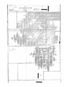
883 Production indicates 688 acres were mined. The northern portion of the source map was merely shaded as “worked out”, which certainly includes many not-mined areas within the mine.
|
| Acres after map date:
|
6
|
General Area of mining acres shown:
|
|
|
|
Shaft, Slope, Drift or Tipple Location(s)
| Type
|
County
|
Township-Range
|
Section
|
Part Section
|
| Main shaft
|
Sangamon
|
16N 3W
|
8
|
NW NW SW
|
| Air shaft
|
Sangamon
|
16N 3W
|
8
|
NW NW SW
|
Geology
Geological Problems Reported
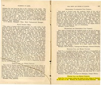
The roof was very good, with 2 to 3 feet of black shale below sandstone cap rock that ranged from 6 inches to 6 feet thick. Carburetted hydrogen gas (“firedamp”) was sometimes found at the face of the entries. The southern part of the mine showed numerous unmined areas that could indicate geologic problems (the areas were not labeled).
Production
| Company
|
Mine Name
|
Date
|
Production (tons)
|
|
|
|
|
|
| Total Production: 3,242,034
|
Production Notes
Coal Report production (if available)
Sources of Data
| Microfilm, document 351218
|
4-18-1924
|
1:2400
|
1:4966
|
Not final
|
Annotated Bibliography (Data source - brief description of information)
| Coal Reports - Production, ownership, years of operation, geologic problems.
|
| Directory of Illinois Coal Mines (Sangamon County) - Mine names, mine index, ownership, years of operation.
|
| Mine notes (Sangamon County) - Mine type, shaft location, seam, depth, thickness, geologic problems.
|
| Microfilm map, document 351218, reel 03134, frames 411, 412 - Shaft locations, mine outline, mining method.
|
Mine Notes
Mine Images
Microfilm: 351218
Map Date: 4-18-1924
Coal Co.: Dawson Coal Mining Co.
Mine Name: Dawson No. 2 Mine
Full Res Download
Photographs
Additional Notes
Additional Notes


