Mine Index Number: 0451
| Company Name:
|
Security Coal and Mining Company
|
| Mine Name:
|
Security No. 1 Mine
|
| Start Date:
|
1907
|
End Date:
|
September 1930
|
| Type of Mine:
|
Underground
|
| Total acres shown:
|
1,089
|
| Acres after map date:
|
18
|
General Area of mining acres shown:
|
|
|
|
Shaft, Slope, Drift or Tipple Location(s)
| Type
|
County
|
Township-Range
|
Section
|
Part Section
|
| Main shaft
|
Perry
|
6S 1W
|
29
|
NE SW SW
|
| Air shaft
|
Perry
|
6S 1W
|
29
|
NE SW SW
|
Geology
| Herrin
|
90
|
7.0
|
12.0
|
8.0
|
MRP
|
Geological Problems Reported
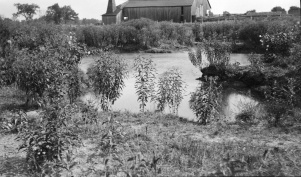
A company mine map noted that Six Mile Creek broke through a north-south entry in March 1923 and flooded the mine or a portion of the mine. The source map used for the mine outline on the accompanying map shows areas under the creek and the pond that were not mined because of the potential for water damage. The roof was gray shale. Top coal was left to support the roof.
Production
| Company
|
Mine Name
|
Date
|
Production (tons)
|
|
|
|
|
|
| Total Production: 6,532,250
|
Production Notes
Coal Report production (if available)
Sources of Data
| Microfilm, document 352118
|
3-1930
|
1:2400
|
1:4303
|
Not final
|
Annotated Bibliography (Data source - brief description of information)
| Coal Reports - Production, ownership, years of operation.
|
| Directory of Illinois Coal Mines (Perry County) - Mine names, mine index, ownership, years of operation.
|
| Mine notes (Perry County) - Mine type, shaft location, seam, depth, thickness, geologic problems.
|
| Microfilm map, document 352118, reel 03138, frames 119-122 - Shaft location, mine outline, mining method.
|
| Company map, ISGS map library, 4103.P42 i5.1-50 - Geologic problems.
|
| WPA, T6S-R1W - Air shaft location.
|
Mine Notes
Mine Images
Photographs
Caption: Subsidence over two rooms east of Security shaft east of the ICRR south of Du Quoin
Credit: Illinois State Geological Survey
Library No.: M-966

