Mine Index Number: 0603
| Company Name:
|
M. and B. Coal Company
|
| Mine Name:
|
M. and B. Mine
|
| Start Date:
|
1923
|
End Date:
|
1939
|
| Type of Mine:
|
Underground
|
| Total acres shown:
|
26
|
| Acres after map date:
|
3
|
General Area of mining acres shown:
|
|
|
|
Shaft, Slope, Drift or Tipple Location(s)
| Type
|
County
|
Township-Range
|
Section
|
Part Section
|
| Main shaft
|
Vermilion
|
19N 12W
|
10
|
SW NE SE
|
| Air shaft
|
Vermilion
|
19N 12W
|
10
|
SW NE SE
|
| Escape shaft
|
Vermilion
|
19N 12W
|
10
|
SW NE SE
|
Geology
Geological Problems Reported
The roof was a gray shale that required about a foot of top coal left to support it. The source map traced from the Vermilion County Recorder’s Office indicates several areas of the mine were filled with water and had to be sealed from the active portions of the mine.
Production
| Company
|
Mine Name
|
Date
|
Production (tons)
|
| M. and B. Coal Company ISGS records indicate M. & B. is an abbreviation for Mauck & Bock Coal Company. Other owners were Louis Bock in 1938, Roy Smith (also in 1938), and C. L. Foster in November 1939 (no production under this owner). The mine was leased in 1939 by a Mr. Gaston, but the mine was idle (due to a foot of water in the works) from February to June 1939.
|
M. and B.
|
1937-1939
|
14,077 Production after map date
|
|
|
|
|
|
|
|
| Total Production: 152,236
|
Production Notes
Coal Report production (if available)
Sources of Data
| Microfilm, document 352909
|
4-15-1937
|
1:1200
|
1:1490
|
Incomplete Not final as well as incomplete
|
| Company, 10-7-13
|
4-15-1936
|
1:720
|
1:720
|
Not final
|
Annotated Bibliography (Data source - brief description of information)
| Coal Reports - Production, ownership, years of operation.
|
| Directory of Illinois Coal Mines (Vermilion County) - Mine names, mine index, ownership, years of operation.
|
| Mine notes (Vermilion County) - Mine type, shaft location, seam, depth, thickness, geologic problems.
|
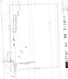
| Microfilm map, document 352909, reel 03141, frame 46 - Shaft locations, mine outline.
|
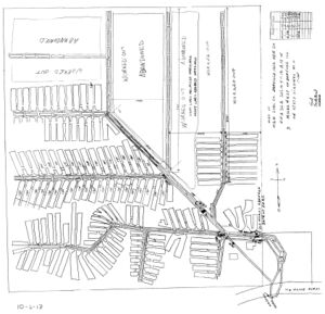
| Company map, courtesy Vermilion County Recorder’s Office, traced, Coal Section files 10-7-13 - Mine outline, mining method.
|
Mine Notes
Mine Images
Coal Section files, traced: 10-7-13
Map Date: 4-15-1936
Coal Co.: M. & B. Coal Company
Mine Name: M. & B. Mine
Full Res Download
Microfilm: 352909
Map Date: 4-15-1937
Coal Co.: M. & B. Coal Company
Mine Name: M. & B. Mine
Full Res Download
Photographs


