Mine Index Number: 0694
| Company Name:
|
V-Day Coal Company
|
| Mine Name:
|
V-Day Mine
|
| Start Date:
|
1945
|
End Date:
|
November 1974
|
| Type of Mine:
|
Underground
|
| Total acres shown:
|
222
|
| Acres after map date:
|
12
|
General Area of mining acres shown:
|
|
|
The northeastern part of the mine was partially stripped out by Mary Moore Mine (mine index 3707).
|
Shaft, Slope, Drift or Tipple Location(s)
| Type
|
County
|
Township-Range
|
Section
|
Part Section
|
| Main slope
|
Vermilion
|
19N 11W
|
30
|
SE NE NE
|
| Air shaft
|
Vermilion
|
19N 11W
|
29
|
SW NW NW
|
Geology
| Herrin
|
117-130
|
|
|
5.25-6.0
|
RPP
|
Geological Problems Reported
The roof was shale over 14 feet thick, and slaking occurred after exposure to the air. After turning the entries north and west, they ran into very treacherous roof conditions, with an abundance of slips. According the to the mine notes, a mine map showed areas of bad roof conditions trending from the southwest quarter of section 20 of T19N-R11W, through the northwest quarter of section 29, toward the slope in the northeast quarter of section 30 and further southwest from there.
Production
| Company
|
Mine Name
|
Date
|
Production (tons)
|
| V-Day Coal Company
|
V-Day
|
1970-1974 Closed due to miner’s strike beginning November 19, 1974 and never reopened.
|
67,500 Production after map date
|
|
|
|
|
|
|
|
| Total Production: 1,200,921
|
Production Notes
Coal Report production (if available)
Sources of Data
| State Archive, MSHA_939
|
11-18-1957
|
1:1200
|
1:1200
|
Not final
|
| State Archive, MSHA_724
|
11-1-1970
|
1:1200
|
1:1200
|
Not final
|
| Company map
|
1960, 1969
|
1:1200
|
1:1330
|
Not final
|
Annotated Bibliography (Data source - brief description of information)
| Coal Reports - Production, ownership, years of operation, depth, thickness.
|
| Directory of Illinois Coal Mines (Vermilion County) - Mine names, mine index, ownership, years of operation.
|
| Mine notes (Vermilion County) - Mine type, slope and air shaft locations, seam, depth, thickness, geologic problems.
|
| State Archive, MSHA_939, courtesy of Robert Gibson, IDNR - Slope & shaft locations, mine outline (NW and central parts of mine), mining method.
|
| State Archive, MSHA_724, courtesy of Robert Gibson, IDNR - Mine outline (SE part of mine).
|
| Company map, courtesy of the Vermilion County Recorder’s Office, 10-8-9 - Mine outline (NE and SW parts of mine).
|
Mine Notes
Mine Images
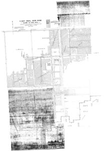
Company:
Map Date: 11-1-1970
Coal Co.: V-Day Coal Company
Mine Name: V-Day Mine
Image Credit: Illinois Department of Natural Resources - Office of Mines and Minerals
Full Res Download
Photographs


