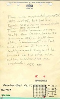
Mine Index Number: 0759
| Company Name:
|
Decatur Coal Company
|
| Mine Name:
|
Decatur No. 1 Mine
|
| Start Date:
|
1879
|
End Date:
|
1914
|
| Type of Mine:
|
Underground
|
| Total acres shown:
|
None A general area of mining on the accompanying map shows the size of the additional area needed to approximate the size of the two contiguous longwall mines. The Decatur No. 2 Mine (mine index 123) probably encompasses some area mined by Decatur No. 1 Mine.
|
| Acres after map date:
|
|
General Area of mining acres shown:
|
|
|
|
Shaft, Slope, Drift or Tipple Location(s)
| Type
|
County
|
Township-Range
|
Section
|
Part Section
|
| Main shaft
|
Macon
|
16N 2E
|
14
|
NW NE NE
|
| Air shaft
|
Macon
|
16N 2E
|
11
|
SE SE SE
|
Geology
| Springfield
|
615
|
|
|
4.17 (4.0-5.0)
|
LW,RPRP in 1910 & 1911
|
Geological Problems Reported
An explosion of fire damp (methane) injured 3 miners in 1886. Another explosion in October 1887 injured 2 miners, so gas was a problem to some extent, especially in the early years. Presumably, better ventilation overcame that threat to the mining. (A 1905 mine fire killed 6 men, but the fire was the result of a cigarette starting a fire near the stables, not gas.) In general, mining conditions were good for longwall mining, with a sturdy shale roof and solid clay floor.
Production
| Company
|
Mine Name
|
Date
|
Production (tons)
|
|
|
|
|
|
| Total Production: 1,782,084
|
Production Notes
Coal Report production (if available)
Sources of Data
| Microfilm, document 352324
|
2-1926
|
1:2400
|
1:5296
|
Not final
|
| Company, 1-32-68
|
5-30-1914
|
1:2400
|
1:2400
|
Not final
|
| WPA, T16N-R2E
|
circa 1934
|
1:12000
|
1:12000
|
Secondary source
|
Annotated Bibliography (Data source - brief description of information)
| Coal Reports - Production, ownership, years of operation, mining method, geologic problems.
|
| Directory of Illinois Coal Mines (Franklin County) - Mine names, mine index, ownership, years of operation.
|
| Mine notes (Macon County) - Mine type, shaft location, seam, depth, thickness, geologic problems.
|
| Microfilm map, document 352324, reel 03138, frame 427 - Shaft locations.
|
| Company map, Coal Section files, 1-32-68 - Shaft location, mine outline (partial).
|
| WPA map, T16N-R2E - Air shaft location.
|
Mine Notes
Mine Images
Company: 1-32-68
Map Date: 5-30-1914
Coal Co.: Decatur Coal Company
Mine Name: Decatur No. 1 Mine
Image Credit: Illinois State Geological Survey
Full Res Download
WPA: T16N-R2E
Map Date: circa 1934
Coal Co.: Decatur Coal Company
Mine Name: Decatur No. 1 Mine
Full Res Download
Photographs