Mine Index Number: 3006
| Company Name:
|
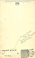
Wagstaff and Smith
|
| Mine Name:
|
Wagstaff and Smith Mine
|
| Start Date:
|
1914
|
End Date:
|
1939
|
| Type of Mine:
|
Underground
|
| Total acres shown:
|
None
|
| Production Indicated Acres:
|
3
|
General Area of mining acres shown:
|
|
|
|
Shaft, Slope, Drift or Tipple Location(s)
| Type
|
County
|
Township-Range
|
Section
|
Part Section
|
| Main shaft
|
Morgan
|
13N 10W
|
30
|
NE SW SW
|
Geology
| Herrin
|
45-65
|
|
|
4.0-4.5
|
Underground
|
Geological Problems Reported
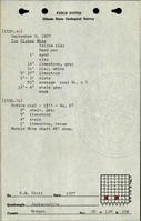
The roof was 1 to 3 feet of clod or soft gray shale under 5 to 10 feet of caprock. The coal seam contained a clay parting, marcasite nodules, and a great deal of pyrite.
Production
| Company
|
Mine Name
|
Date
|
Production (tons)
|
Production Notes
Coal Report production (if available)
Sources of Data
| ISGS field notes (K. W. Stott)
|
9-9-1927
|
1:62500
|
1:62500
|
Secondary source
|
Annotated Bibliography (Data source - brief description of information)
| Coal Reports - Production, ownership, years of operation.
|
| Directory of Illinois Coal Mines (Morgan County) - Mine names, mine index, ownership, years of operation.
|
| Mine notes (Morgan County) - Mine type, seam, depth, thickness.
|
| ISGS field notes (Morgan County) - Shaft location, geologic problems.
|
Mine Notes
Mine Images
Photographs