Mine Index Number: 3624
| Company Name:
|
Egyptian Coal and Mining Company
|
| Mine Name:
|
Advance Mine
|
| Start Date:
|
1887
|
End Date:
|
1913
|
| Type of Mine:
|
Underground
|
| Total acres shown:
|
57
|
| Acres after map date:
|
5
|
General Area of mining acres shown:
|
|
|
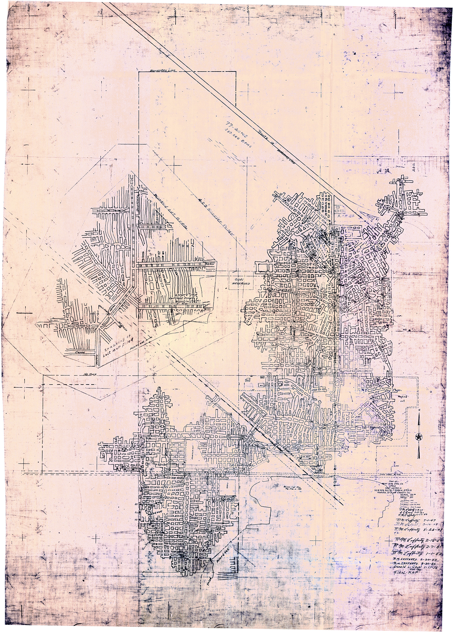
The outline shown on the accompanying map is smaller than expected for the production included in the source map; the production indicates the mine would be approximately 75 acres. It is possible that pillars were robbed, but it is unlikely that pillar extraction would be enough to explain the size difference.
|
Shaft, Slope, Drift or Tipple Location(s)
| Type
|
County
|
Township-Range
|
Section
|
Part Section
|
| Main shaft (6 x 12 feet)
|
St. Clair
|
3S 6W
|
28
|
NE NE NE
|
| Air shaft
|
St. Clair
|
3S 6W
|
28
|
NE NE NE
|
Geology
Geological Problems Reported
In some places, the roof was soapstone that ranged from 0 to 4 feet thick. Where the soapstone was not present, the roof was shale or limestone.
Production
| Company
|
Mine Name
|
Date
|
Production (tons)
|
|
|
|
|
|
| Total Production: 490,468
|
Production Notes
Coal Report production (if available)
Sources of Data
| Microfilm, document 351122
|
7-19-1910
|
1:1200
|
1:1986
|
Not final
|
Annotated Bibliography (Data source - brief description of information)
| Coal Reports - Production, ownership, years of operation, mine type, seam, depth, thickness.
|
| Directory of Illinois Coal Mines (St. Clair County) - Mine names, mine index, ownership, years of operation.
|
| Mine notes (St. Clair County) - Shaft location.
|
| Microfilm map, document 351122, reel 03134, frames 255 & 256 - Shaft locations, mine outline, mining method.
|
| Microfilm map, document 351010, reel 03134, frame 84 - Main shaft location.
|
Mine Notes
Mine Images
![[[:Advance|Advance]]](https://wikiimage.isgs.illinois.edu/ilmines/st_clair/thumbnails/m3624_PC_155_01_th.jpg) These files may not be true to scale and are not georgistered. These files may not be true to scale and are not georgistered.
|
Map Type:
|
State Archive
|
| Map ID:
|
PC_155_01
|
| Company:
|
Advance Coal Company
|
| Mine Name:
|
Advance
|
| Caption:
|
|
| Map Date:
|
04-25-1908
|
| Map Status:
|
Not Final
|
| Image Credit:
|
|
| Note:
|
Used for Shaft Locations
|
| More Info:
|
M3624 PC 155 01
|
| Full Res Download:These files are true to scale and most are georegistered for gis software. These files may be a very large (>1GB) download!
|
https://wikiimage.isgs.illinois.edu/ilmines/st clair/m3624 PC 155 01.zip
|
 These files may not be true to scale and are not georgistered. These files may not be true to scale and are not georgistered.
|
Map Type:
|
State Archive
|
| Map ID:
|
IL_108_01
|
| Company:
|
|
| Mine Name:
|
|
| Caption:
|
|
| Map Date:
|
1-17-1956
|
| Map Status:
|
Final
|
| Image Credit:
|
|
| Note:
|
Final Map for Mine index 3619
Secondary Source for Mine Index 3620
Secondary Source for Mine Index 3624
|
| More Info:
|
M3619 IL 108 01
|
| Full Res Download:These files are true to scale and most are georegistered for gis software. These files may be a very large (>1GB) download!
|
https://wikiimage.isgs.illinois.edu/ilmines/st clair/m3619 IL 108 01.zip
|
Photographs
![[[:Advance|Advance]]](https://wikiimage.isgs.illinois.edu/ilmines/st_clair/thumbnails/m3624_IL_174_01_th.jpg)