Mine Index Number: 3630
| Company Name:
|
Ubben Coal Company
|
| Mine Name:
|
Ubben No. 1 Mine
|
| Start Date:
|
1890
|
End Date:
|
April 1938
|
| Type of Mine:
|
Underground
|
| Total acres shown:
|
197
|
| Production Indicated Acres:
|
14
|
General Area of mining acres shown:
|
|
|
The area shown on the accompanying map is smaller than expected for the reported production. A general area of mining was added on the western side of the mine, which the source map indicated was worked out. Another general area of mining is shown on the accompanying map where the source map indicated a separate old mine whose works were not known or the extent delineated. Some of this area is known to be the Bohlander Mine (mine index 7389), but other operators may have worked in the vicinity.
|
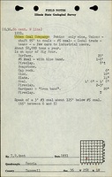
Shaft, Slope, Drift or Tipple Location(s)
| Type
|
County
|
Township-Range
|
Section
|
Part Section
|
| Main shaft
|
Tazewell
|
24N 5W
|
1
|
NE SW SW
|
| Air shaft
|
Tazewell
|
24N 5W
|
1
|
NE SW SW
|
Geology
Geological Problems Reported
Production
| Company
|
Mine Name
|
Date
|
Production (tons)
|
|
|
|
|
|
| Total Production: 1,217,196
|
Production Notes
Coal Report production (if available)
Sources of Data
| Microfilm, document 352854
|
1-7-1936
|
1:2400
|
1:4634
|
Not final
|
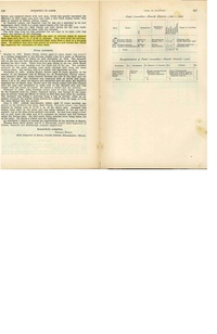
Annotated Bibliography (Data source - brief description of information)
| Coal Reports - Production, ownership, years of operation.
|
| Directory of Illinois Coal Mines (Tazewell County) - Mine names, mine index, ownership, years of operation.
|
| Mine notes (Tazewell County) - Mine type, shaft location, seam, depth, thickness.
|
| Microfilm map, document 351418, reel 03136, frame 53 - Shaft locations, mine outline, mining method.
|
Mine Notes
Mine Images
 These files may not be true to scale and are not georgistered. These files may not be true to scale and are not georgistered.
|
Map Type:
|
Microfilm
|
| Map ID:
|
352854 03140, 471, 28x
|
| Company:
|
Ubben Coal Company
|
| Mine Name:
|
|
| Caption:
|
|
| Map Date:
|
1-7-1936
|
| Map Status:
|
Not Final
|
| Image Credit:
|
|
| Note:
|
|
| More Info:
|
M3630
|
| Full Res Download:These files are true to scale and most are georegistered for gis software. These files may be a very large (>1GB) download!
|
https://wikiimage.isgs.illinois.edu/ilmines/tazewell/m3630.zip
|
Photographs