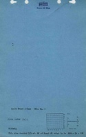
Mine Index Number: 3631
| Company Name:
|
William Grant
|
| Mine Name:
|
Grant No. 1 Mine
|
| Start Date:
|
Circa 1870
|
End Date:
|
1892
|
| Type of Mine:
|
Underground
|
| Total acres shown:
|
7
|
| Production Indicated Acres:
|
40
|
General Area of mining acres shown:
|
|
|
|
Shaft, Slope, Drift or Tipple Location(s)
| Type
|
County
|
Township-Range
|
Section
|
Part Section
|
| Main shaft
|
Tazewell
|
24N 5W
|
1
|
SW NW NE
|
| Air shaft
|
Tazewell
|
24N 5W
|
1
|
SW NW NE
|
Geology
| Springfield
|
120
|
|
|
4.0-4.5
|
RP
|
Geological Problems Reported
The 1884 Coal Report indicated black damp (carbonic acid gas) problems from the extensive old works.
Production
| Company
|
Mine Name
|
Date
|
Production (tons)
|
| David M. Alexander
|
Hope
|
ca. 1870-1880
|
UnknownProduction prior to 1882 is unknown. The 1884 Coal Report stated that the mine began operating 14 years previously. In 1882, the main entry was 1,350 feet long, indicating substantial production before the Coal Reports were published. A mine was shown on the 1873 atlas at the location noted above.
|
|
|
|
|
|
|
|
| Total Production: 154,839
|
Production Notes
Coal Report production (if available)
Sources of Data
| Microfilm, document 352850
|
4-30-1880
|
1:1200
|
1:2234
|
Not final
|
Annotated Bibliography (Data source - brief description of information)
| Coal Reports - Production, ownership, years of operation, mine type, seam, depth, thickness, geologic problems.
|
| Directory of Illinois Coal Mines (Tazewell County) - Mine names, mine index, ownership, years of operation.
|
| Microfilm map, document 352850, reel 03140, frame 467 - Shaft locations, mine outline, mining method.
|
| Andreas, A. T., 1873, Atlas Map of Tazewell County, Illinois - Shaft location.
|
Mine Notes
Mine Images
 These files may not be true to scale and are not georgistered. These files may not be true to scale and are not georgistered.
|
Map Type:
|
Atlas
|
| Map ID:
|
1873 Atlas of Tazewell County
|
| Company:
|
|
| Mine Name:
|
|
| Caption:
|
|
| Map Date:
|
1873
|
| Map Status:
|
Secondary
|
| Image Credit:
|
|
| Note:
|
|
| More Info:
|
Mh sec1
|
| Full Res Download:These files are true to scale and most are georegistered for gis software. These files may be a very large (>1GB) download!
|
https://wikiimage.isgs.illinois.edu/ilmines/tazewell/mh sec1.zip
|
![[[:Hope|Hope]]](https://wikiimage.isgs.illinois.edu/ilmines/tazewell/thumbnails/m3631_th.jpg) These files may not be true to scale and are not georgistered. These files may not be true to scale and are not georgistered.
|
Map Type:
|
Microfilm
|
| Map ID:
|
352850 03140, 467, 27x
|
| Company:
|
|
| Mine Name:
|
Hope
|
| Caption:
|
|
| Map Date:
|
4-30-1880
|
| Map Status:
|
Not Final
|
| Image Credit:
|
|
| Note:
|
|
| More Info:
|
M3631
|
| Full Res Download:These files are true to scale and most are georegistered for gis software. These files may be a very large (>1GB) download!
|
https://wikiimage.isgs.illinois.edu/ilmines/tazewell/m3631.zip
|
Photographs