Mine Index Number: 3985
| Company Name:
|
Unknown
|
| Mine Name:
|
|
| Start Date:
|
Unknown
|
End Date:
|
Unknown
|
| Type of Mine:
|
Surface
|
| Total acres shown:
|
None
|
| Acres after map date:
|
|
General Area of mining acres shown:
|
|
|
|
Shaft, Slope, Drift or Tipple Location(s)
| Type
|
County
|
Township-Range
|
Section
|
Part Section
|
| Pit
|
Franklin
|
5S 3E
|
21
|
NE SW NW
|
Geology
| Flannigan
|
|
|
2.0
|
1.33
|
Surface
|
Geological Problems Reported
Production
| Company
|
Mine Name
|
Date
|
Production (tons)
|
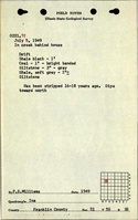
| Unknown This mine location may have been part of the King Mine (mine index 2068). The field notes included a statement that it had been mined 16 to 18 years before, which would be in the time when Wanless visited the King Mine location.
|
|
|
|
|
|
Production Notes
Coal Report production (if available)
Sources of Data
| ISGS field notes (F. E. Williams)
|
7-5-1949
|
(text only)
|
1:24000 Point plotted onto 1:24,000 USGS topographic map and digitized.
|
Secondary source
|
Annotated Bibliography (Data source - brief description of information)
| Coal Reports - Production, ownership, years of operation.
|
| Directory of Illinois Coal Mines (Franklin County) - Mine names, mine index, ownership, years of operation.
|
| ISGS field notes (Franklin County) - Mine type, mine location, seam, thickness.
|
Mine Notes
Mine Images
Photographs
Additional Notes