Rend Lake Dam Quadrangle
Mining in the Rend Lake Dam Quadrangle
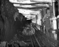
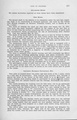
Methane gas seeping from the coal was a serious problem in Franklin County; 16 men were killed in explosions in the mines that operated in the Rend Lake Dam Quadrangle. Ventilation was good at the working faces, but gas would accumulate behind stoppings that shut off the abandoned areas of the mines, and the stoppings were not always airtight. Factors that contributed to the mines’ problems were open flames in miners lamps and coal dust that would promulgate the explosion throughout the mine. The open flames in the miners lamps were a known hazard, but the introduction of closed lamps caused serious labor antagonism, since the lamps only provided about 2 candlepower of illumination. The gradual development of 100-candlepower lamps eased acceptance of the battery-powered lights. Rock dusting required development also, although the process was known in 1917. Lime dust was often too coarse to apply effectively. Old Ben Coal Company worked aggressively to develop a shale dust and this was used from 1918 until 1928, when lime rock dust became available in paper bags.
The Herrin Coal was very thick in Franklin County, reaching a maximum thickness of 11.5 feet in the Rend Lake Dam Quadrangle, and was over 600 feet deep at most of the mines. Old Ben No. 14 (mine index 665) operated the longest of the mines in this quadrangle, running for 49 years.
Old Ben No. 14 (mine index 665) and Old Ben No. 24 (mine index 866) had several large faults passing through the workings. These faults are part of the Rend Lake Fault Zone, and had offsets up to 55 feet. For details on the Rend Lake Fault System, see ISGS Circular 513, noted in the Reference section on page 8 of this report.
Map and Directory PDF Download
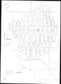
Coal Mines In Illinois Rend Lake Dam Quadrangle
Mines that Appear on the Rend Lake Dam Quadrangle
Unlocated Mines
Franklin County
Pages in category "Rend Lake Dam Quadrangle"
The following 9 pages are in this category, out of 9 total.
Media in category "Rend Lake Dam Quadrangle"
The following 29 files are in this category, out of 29 total.
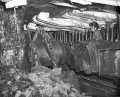
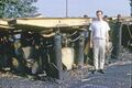 1960s Old Ben 21 Rheinstahl-Wanheim 4 leg chocks MI 863.jpg 3,000 × 1,997; 209 KB
 1964 Rheinstahl-Wanheim 6 leg Chocks Old Ben 21 used Face 3 2.jpg 2,530 × 1,776; 515 KB
 1964 Rheinstahl-Wanheim 6 leg Chocks Old Ben 21 used Face 3.jpg 2,530 × 1,686; 545 KB
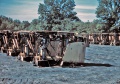
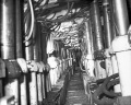
 1969 Jun-1970 Apr Old Ben 21 Face 6 Gullick Chocks 1.jpg 2,863 × 2,291; 575 KB
 1969 Jun-1970 Apr Old Ben 21 Face 6 Gullick Chocks 2.jpg 3,000 × 2,414; 511 KB
 1969 Jun-1970 Apr Old Ben 21 Face 6 Gullick Chocks 3.jpg 3,000 × 2,411; 471 KB
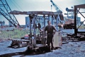
 1969 Jun-1970 Apr Old Ben 21 Joy-Gullick 600 ton Chocks used on Face 6 4.jpg 3,000 × 2,005; 220 KB
 1969 Jun-1970 Apr Old Ben 21 Joy-Gullick 600 ton Chocks used on Face 6.jpg 3,000 × 2,027; 248 KB
 M0056 coalreport 1907.pdf 587 × 966; 116 KB
 M0056 coalreport 1909.pdf 716 × 1,193, 2 pages; 760 KB
 M0056 minenotes.pdf 739 × 1,193, 18 pages; 4.76 MB
 M0056.jpg 3,390 × 1,436; 1.12 MB
 M0139 coalreport 1914.pdf 825 × 1,264; 568 KB
 M0139 minenotes.pdf 739 × 1,193, 19 pages; 5.3 MB
 M0139.jpg 3,390 × 2,452; 1.76 MB
 M0665 coalreport 1912.pdf 795 × 1,241, 4 pages; 13.25 MB
 M0665 minenotes.pdf 739 × 1,193, 15 pages; 4.12 MB
 M0665wrp.jpg 3,371 × 3,390; 4.25 MB
 M0863 minenotes.pdf 739 × 1,193, 182 pages; 22.63 MB
 M0863wrp.jpg 3,390 × 2,317; 3.39 MB
 M0866 minenotes.pdf 739 × 1,193, 26 pages; 6.65 MB
 M0866.jpg 3,106 × 3,800; 4.87 MB
 M0879 minenotes.pdf 739 × 1,193, 83 pages; 27.61 MB
 M0879wrp.jpg 3,390 × 1,473; 1.69 MB
 M2068 fieldnotes.pdf 747 × 1,191, 2 pages; 308 KB
 M2070 coalreport 1917p249.pdf 602 × 991; 92 KB
 M2070 minenotes.pdf 739 × 1,193, 15 pages; 3.76 MB
 M2070mrg.jpg 2,483 × 3,390; 1.06 MB
 M3985 fieldnotes.pdf 754 × 1,204, 2 pages; 270 KB


