Mine Index Number: 4013
| Company Name:
|
Roy Wilson Coal Company
|
| Mine Name:
|
Wilson No. 1 Mine
|
| Start Date:
|
1929
|
End Date:
|
1931
|
| Type of Mine:
|
Underground
|
| Total acres shown:
|
None
|
| Acres after map date:
|
Less than 1
|
General Area of mining acres shown:
|
|
|
Not Shown On Map. Not shown on accompanying map; the area was later surface mined by various small mines.
|
Shaft, Slope, Drift or Tipple Location(s)
| Type
|
County
|
Township-Range
|
Section
|
Part Section
|
| Main slope
|
Williamson
|
9S 2E
|
1
|
1200 FSL, 300 FEL
|
Geology
Geological Problems Reported
Production
| Company
|
Mine Name
|
Date
|
Production (tons)
|
Production Notes
Coal Report production (if available)
Sources of Data
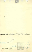
| Mine notes
|
Undated
|
(text only)
|
1:24000 Point plotted onto 1:24,000 USGS quadrangle and digitized.
|
Secondary source
|
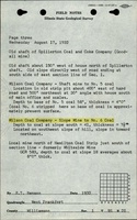
| ISGS field notes (E. T. Benson)
|
8-17-1932
|
(text only)
|
1:24000 Point plotted onto 1:24,000 USGS quadrangle and digitized.
|
Secondary source
|
Annotated Bibliography (Data source - brief description of information)
| Coal Reports - Production, ownership, years of operation, mining method.
|
| Directory of Illinois Coal Mines (Williamson County) - Mine names, mine index, ownership, years of operation.
|
| Mine notes (Williamson County) - Mine type, slope location, seam, depth, thickness.
|
| ISGS field notes (Williamson County) - Mine type, slope location, seam, depth, thickness.
|
Mine Notes
Mine Images
Photographs