Mine Index Number: 4096
| Company Name:
|
Charles Burch
|
| Mine Name:
|
Burch Mine
|
| Start Date:
|
1923
|
End Date:
|
1937
|
| Type of Mine:
|
Underground
|
| Total acres shown:
|
15
|
| Acres after map date:
|
|
General Area of mining acres shown:
|
|
|
This mine was later partially stripped out by Delta Mine (mine index 0702).
|
Shaft, Slope, Drift or Tipple Location(s)
| Type
|
County
|
Township-Range
|
Section
|
Part Section
|
| Main slope
|
Williamson
|
9S 4E
|
21
|
NE SE NE
|
| Air shaft
|
Williamson
|
9S 4E
|
21
|
NE SE NE
|
Geology
| Herrin
|
22
|
5.5
|
7.0
|
5.67
|
MRP
|
Geological Problems Reported
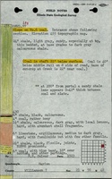
The roof was light gray shale that made a sharp contact with the coal. Small concretions were present in the roof. A very thin shale parting was present 1.5 feet below the top of the seam. Pyrite concretions were present in the coal. Mining in the western part of the mine was halted by a fault.
Production
| Company
|
Mine Name
|
Date
|
Production (tons)
|
Production Notes
Coal Report production (if available)
Sources of Data
| State archive, msha_623_01
|
11-1-1937
|
1:1200
|
1:1200
|
Final
|
Annotated Bibliography (Data source - brief description of information)
| Coal Reports - Production, ownership, years of operation.
|
| Directory of Illinois Coal Mines (Williamson County) - Mine names, mine index, ownership, years of operation.
|
| Mine notes (Williamson County) - Mine type, slope location, seam, thickness, geologic problems.
|
| ISGS field notes (Williamson County) - Depth, geologic problems.
|
| State archive map, msha_623_01 - Slope and shaft locations, mine outline, mining method.
|
Mine Notes
Mine Images
![[[:Burch|Burch]]](https://go.illinois.edu/ILMImages/williamson/thumbnails/m4096_msha_623_01_th.jpg) These files may not be true to scale and are not georgistered. These files may not be true to scale and are not georgistered.
|
Map Type:
|
State Archive
|
| Map ID:
|
msha_623_01
|
| Company:
|
Charles Burch
|
| Mine Name:
|
Burch
|
| Caption:
|
|
| Map Date:
|
11-01-1937
|
| Map Status:
|
Final
|
| Image Credit:
|
|
| Note:
|
|
| More Info:
|
M4096 msha 623 01
|
| Full Res Download:These files are true to scale and most are georegistered for gis software. These files may be a very large (>1GB) download!
|
https://go.illinois.edu/ILMImages/williamson/m4096 msha 623 01.zip
|
Photographs