Mine Index Number: 4159
| Company Name:
|
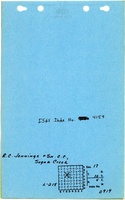
R. C. Jennings and Son Coal Company
|
| Mine Name:
|
Jennings Mine
|
| Start Date:
|
1956
|
End Date:
|
October 1956
|
| Type of Mine:
|
Surface
|
| Total acres shown:
|
None
|
| Production Indicated Acres:
|
2
|
General Area of mining acres shown:
|
|
|
This mine is in an area that was later enlarged by the Will Scarlet Mine (mine index 0697).
|
Shaft, Slope, Drift or Tipple Location(s)
| Type
|
County
|
Township-Range
|
Section
|
Part Section
|
| Tipple / pit
|
Williamson
|
10S 4E
|
17
|
SE NW
|
Geology
| Dekoven
|
10-20
|
|
|
3.0
|
Surface
|
Geological Problems Reported
Production
| Company
|
Mine Name
|
Date
|
Production (tons)
|
Production Notes
Coal Report production (if available)
Sources of Data
| Mine notes
|
Undated
|
(text only)
|
1:24000 Point plotted onto 1:24,000 USGS quadrangle and digitized.
|
Secondary source
|
Annotated Bibliography (Data source - brief description of information)
| Coal Reports - Production, ownership, years of operation.
|
| Directory of Illinois Coal Mines (Williamson County) - Mine names, mine index, ownership, years of operation.
|
| Mine notes (Williamson County) - Mine type, mine location, seam, depth, thickness.
|
Mine Notes
Mine Images
Photographs