Mine Index Number: 4700
| Company Name:
|
Storme Mining Company
|
| Mine Name:
|
Storme No. 1 Mine
|
| Start Date:
|
1964
|
End Date:
|
October 1964
|
| Type of Mine:
|
Surface
|
| Total acres shown:
|
26
|
| Acres after map date:
|
|
General Area of mining acres shown:
|
|
|
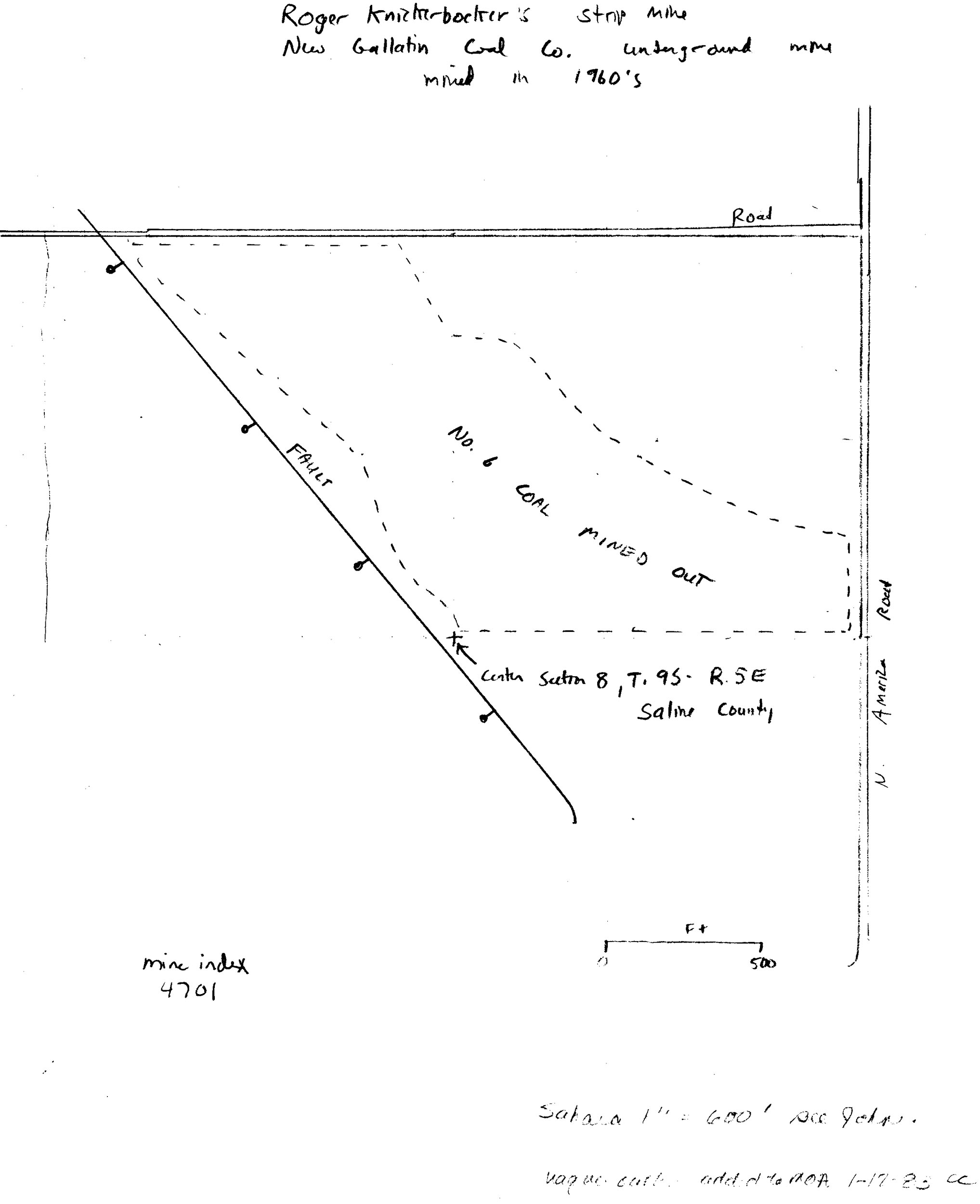
This outline was labeled Knickerbocker Mine (index 4701) on the surface mine updates, but no production was reported for the Knickerbocker Mine, while the production reported for the Storme Mine is consistent with the mine outline. Knickerbocker may have extended mining in this pit.
|
Shaft, Slope, Drift or Tipple Location(s)
| Type
|
County
|
Township-Range
|
Section
|
Part Section
|
| Pit
|
Saline
|
9S 5E
|
8
|
NE SE NW
|
Geology
Geological Problems Reported
Production
| Company
|
Mine Name
|
Date
|
Production (tons)
|
Production Notes
Coal Report production (if available)
Sources of Data
| Coal Section files
|
Undated
|
1:4800
|
1:4800
|
Secondary source
|
Annotated Bibliography (Data source - brief description of information)
| Coal Reports - Production, ownership, years of operation, seam, depth, thickness, mining method.
|
| Directory of Illinois Coal Mines (Saline County) - Mine names, mine index, ownership, years of operation, location.
|
| Coal Section files, surface mine updates, outline shown for Knickerbocker Mine (mine index 4701) - Mine outline.
|
Mine Notes
Mine Images
 These files may not be true to scale and are not georgistered. These files may not be true to scale and are not georgistered.
|
Map Type:
|
Strip mine updates
|
| Map ID:
|
Strip mine updates
|
| Company:
|
|
| Mine Name:
|
|
| Caption:
|
|
| Map Date:
|
|
| Map Status:
|
Secondary
|
| Image Credit:
|
|
| Note:
|
|
| More Info:
|
M4701.jpg
|
| Full Res Download:These files are true to scale and most are georegistered for gis software. These files may be a very large (>1GB) download!
|
https://wikiimage.isgs.illinois.edu/ilmines/saline/m4701.zip
|
![[[:Storme No. 1|Storme No. 1]]](https://go.illinois.edu/ILMImages/saline/thumbnails/7a-02-08_geo_th.jpg) These files may not be true to scale and are not georgistered. These files may not be true to scale and are not georgistered.
|
Map Type:
|
Department of Mines & Minerals
|
| Map ID:
|
7a-02-08
|
| Company:
|
Storme Mining Company
|
| Mine Name:
|
Storme No. 1
|
| Caption:
|
|
| Map Date:
|
Undated
|
| Map Status:
|
Secondary
|
| Image Credit:
|
|
| Note:
|
|
| More Info:
|
7a-02-08
|
| Full Res Download:These files are true to scale and most are georegistered for gis software. These files may be a very large (>1GB) download!
|
https://go.illinois.edu/ILMImages/saline/7a-02-08 geo.zip
|
Photographs