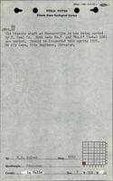
Mine Index Number: 5543
| Company Name:
|
Heenanville Coal Company
|
| Mine Name:
|
Heenanville Mine
|
| Start Date:
|
1901
|
End Date:
|
1926
|
| Type of Mine:
|
Underground
|
| Total acres shown:
|
15
|
| Acres after map date:
|
|
General Area of mining acres shown:
|
|
|
|
Shaft, Slope, Drift or Tipple Location(s)
| Type
|
County
|
Township-Range
|
Section
|
Part Section
|
| Main shaft
|
La Salle
|
31N 3E
|
3
|
SW SW SW
|
| Air shaft
|
La Salle
|
31N 3E
|
3
|
SW SW SW
|
Geology
Geological Problems Reported
Production
| Company
|
Mine Name
|
Date
|
Production (tons)
|
|
|
|
|
|
| Total Production: 155,079
|
Production Notes
Coal Report production (if available)
Sources of Data
| Microfilm, document 352436
|
1-3-1955
|
1:1200
|
1:2731
|
Secondary source
|
Annotated Bibliography (Data source - brief description of information)
| Coal Reports - Production, ownership, years of operation, mine type, seam, depth, thickness, mining method.
|
| Directory of Illinois Coal Mines (La Salle County) - Mine names, mine index, ownership, years of operation.
|
| ISGS field notes (La Salle County) - Shaft location.
|
| Microfilm map, document 352436, reel 03139, frame 11, map of French Mine (mine index 620) - Mine outline, shaft locations, mining method.
|
Mine Notes
Mine Images
Photographs