Mine Index Number: 6637
| Company Name:
|
Unknown
|
| Mine Name:
|
Unknown Mine
|
| Start Date:
|
Before 1871
|
End Date:
|
Unknown
|
| Type of Mine:
|
Underground
|
| Total acres shown:
|
None
|
| Acres after map date:
|
|
General Area of mining acres shown:
|
|
|
|
Shaft, Slope, Drift or Tipple Location(s)
| Type
|
County
|
Township-Range
|
Section
|
Part Section
|
| Mine
|
Fulton
|
4N 2E
|
6
|
NE NE SE
|
Geology
Geological Problems Reported
Production
| Company
|
Mine Name
|
Date
|
Production (tons)
|
Production Notes
Coal Report production (if available)
Sources of Data
| ISGS field notes (G. H. Cady)
|
undated
|
1:62500
|
1:62500
|
Secondary source
|
| Atlas of Fulton County
|
1871
|
|
|
Secondary source
|
Annotated Bibliography (Data source - brief description of information)
| ISGS field notes (Fulton County) - Mine location, seam.
|
| Andreas, Lyter & Co., 1871, Atlas Map of Fulton County, Illinois, Davenport, Iowa - Mine location, operating years.
|
Mine Notes
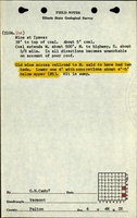
Mine Images
 These files may not be true to scale and are not georgistered. These files may not be true to scale and are not georgistered.
|
Map Type:
|
1871 Atlas of Fulton County
|
| Map ID:
|
Anreas, Lyter & Co., 1871, Atlas Map of Fulton County, Illinois, Davenport, Iowa.
|
| Company:
|
|
| Mine Name:
|
|
| Caption:
|
|
| Map Date:
|
1871
|
| Map Status:
|
|
| Image Credit:
|
|
| Note:
|
Only shows the area near Ipava, mines highlighted in yellow
|
| More Info:
|
1871 atlas ipava
|
| Full Res Download:These files are true to scale and most are georegistered for gis software. These files may be a very large (>1GB) download!
|
https://go.illinois.edu/ILMImages/fulton/1871 atlas ipava.jpg
|
Photographs