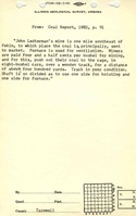
Mine Index Number: 7387
| Company Name:
|
John Ledterman
|
| Mine Name:
|
Empire Mine
|
| Start Date:
|
1878
|
End Date:
|
1886
|
| Type of Mine:
|
Underground
|
| Total acres shown:
|
None
|
| Production Indicated Acres:
|
24
|
General Area of mining acres shown:
|
|
|
|
Shaft, Slope, Drift or Tipple Location(s)
| Type
|
County
|
Township-Range
|
Section
|
Part Section
|
| Main shaft
|
Tazewell
|
24N 5W
|
1
|
NE SWThe location is from the land ownership on the 1873 atlas, combined with the 1885 Coal Report discussion of the mine, in which the location was stated to be adjacent to the Rundle Mine (mine index 7389). It is possible that Ledterman’s mine may have been the mine shown on the 1873 atlas and subsequently named mine index 7388. An escapement shaft is known from the 1885 Coal Report, located 300 feet from the hoisting shaft. Because the direction is not known and the shaft location is very general, the escape shaft is not shown on the accompanying map.
|
Geology
| Springfield
|
90-100
|
|
|
4.0-4.5
|
RP
|
Geological Problems Reported
Production
| Company
|
Mine Name
|
Date
|
Production (tons)
|
| John Ledterman
|
Empire
|
1878-1886Production and years of operation before the 1879 Coal Report is not known. The mine may have operated after 1886 as well. See the unlocated mines at the back of this report; Pekin Coal Association may have operated at this location.
|
90,332
|
|
|
Production Notes
Coal Report production (if available)
Sources of Data
| Atlas Map of Tazewell County
|
1873
|
1:9457
|
1:9457
|
Secondary source
|
Annotated Bibliography (Data source - brief description of information)
| Coal Reports - Production, ownership, years of operation, mine type, seam, depth, thickness, mining method.
|
| Directory of Illinois Coal Mines (Tazewell County) - Mine names, mine index, ownership, years of operation.
|
| Andreas, A. T., 1873, Atlas Map of Tazewell County, Illinois: Davenport, Iowa, Andreas, Lyter & Co., 165p. - Shaft location.
|
Mine Notes
Mine Images
 These files may not be true to scale and are not georgistered. These files may not be true to scale and are not georgistered.
|
Map Type:
|
Atlas
|
| Map ID:
|
1873 Atlas of Tazewell County
|
| Company:
|
|
| Mine Name:
|
|
| Caption:
|
|
| Map Date:
|
1873
|
| Map Status:
|
Secondary
|
| Image Credit:
|
|
| Note:
|
|
| More Info:
|
Mh sec1
|
| Full Res Download:These files are true to scale and most are georegistered for gis software. These files may be a very large (>1GB) download!
|
https://wikiimage.isgs.illinois.edu/ilmines/tazewell/mh sec1.zip
|
Photographs