Mine Index Number: 7882
| Company Name:
|
Unknown
|
| Mine Name:
|
Unknown Mine
|
| Start Date:
|
Circa 1889
|
End Date:
|
Unknown
|
| Type of Mine:
|
Unknown
|
| Total acres shown:
|
|
| Acres after map date:
|
|
General Area of mining acres shown:
|
|
|
|
Shaft, Slope, Drift or Tipple Location(s)
| Type
|
County
|
Township-Range
|
Section
|
Part Section
|
| Shaft
|
Macoupin
|
7N 9W
|
27
|
SE NE SE
|
Geology
Geological Problems Reported
Production
| Company
|
Mine Name
|
Date
|
Production (tons)
|
Production Notes
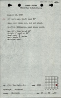
Field notes indicate some coal was taken out, but coal was not mined.
Coal Report production (if available)
Sources of Data
| ISGS field notes (J. R. Van Pelt, Jr.)
|
1929
|
1:62500
|
1:62500
|
Secondary source
|
Annotated Bibliography (Data source - brief description of information)
| Directory of Illinois Coal Mines (Macoupin County) - Mine location.
|
| ISGS field notes (Macoupin County) - Shaft location, depth.
|
Mine Notes
Mine Images
Photographs