Category:Mine Subsidence
Photographs

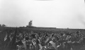
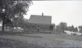
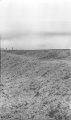
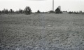
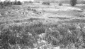
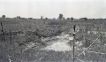
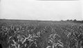
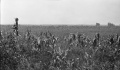
Caption: Drowned-out area of corn near Nokomis where the 8 foot coal bed is worked at a depth of about 625 feet.
Credit: Illinois State Geological Survey
Date: Pre-1914
Library No.: M-1000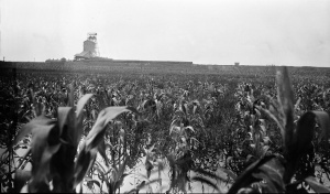
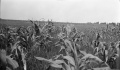
Caption: Drowned-out area of corn near Nokomis where the 8 foot coal bed is worked at a depth of about 625 feet.
Credit: Illinois State Geological Survey
Date: Pre-1914
Library No.: M-1001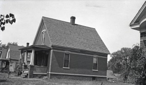
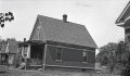
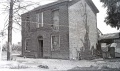
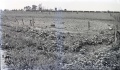
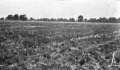
Caption: Houses in northwest Springfield for which claims were paid by a mining company for damages caused by mining coal 5 feet 9 inches thick at a depth of about 200 feet.
Credit: Illinois State Geological Survey
Date: Pre-1914
Publication: Fig. 44 Cooperative Bulletin 17 – Subsidence in Illinois
Library No.: M-1003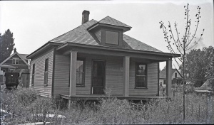
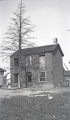
Caption: Houses in northwest Springfield for which claims were paid by a mining company for damages caused by mining coal 5 feet 9 inches thick at a depth of about 200 feet.
Credit: Illinois State Geological Survey
Date: Pre-1914
Library No.: M-1005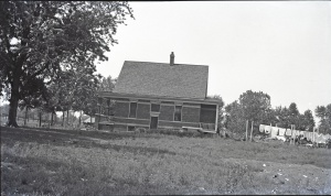
Caption: Houses in northwest Springfield for which claims were paid by a mining company for damages caused by mining coal 5 feet 9 inches thick at a depth of about 200 feet. See M-1004
Credit: Illinois State Geological Survey
Library No.: M-1006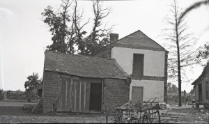
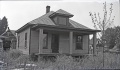
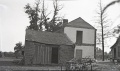
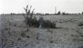
Caption: Brick house near Danville abandoned on account of danger by room-and-pillar mining of a 6-foot coal at a depth of about 200 feet.
Credit: Illinois State Geological Survey
Date: Pre-1914
Publication: Fig. 42 Cooperative Bulletin 17 – Subsidence in Illinois
Library No.: M-1007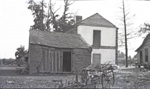
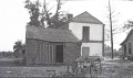
Caption: Brick house near Danville abandoned on account of danger by room-and-pillar mining of a 6-foot coal at a depth of about 200 feet.
Credit: Illinois State Geological Survey
Date: Pre-1914
Library No.: M-1008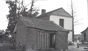
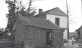
Caption: Brick house near Danville abandoned on account of danger by room-and-pillar mining of a 6-foot coal at a depth of about 200 feet.
Credit: Illinois State Geological Survey
Date: Pre-1914
Library No.: M-1009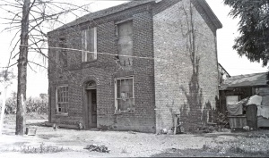
Caption: Brick house near Danville abandoned on account of danger by room-and-pillar mining of a 6-foot coal at a depth of about 200 feet.
Credit: Illinois State Geological Survey
Date: Pre-1914
Library No.: M-1010
Caption: Brick house near Danville abandoned on account of danger by room-and-pillar mining of a 6-foot coal at a depth of about 200 feet.
Credit: Illinois State Geological Survey
Date: Pre-1914
Library No.: M-1011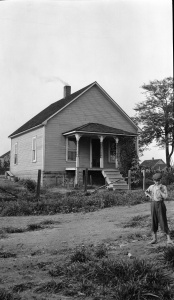
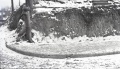
Caption: Plaster and foundation cracked.
Credit: Illinois State Geological Survey
Date: Pre-1914
Library No.: M-1003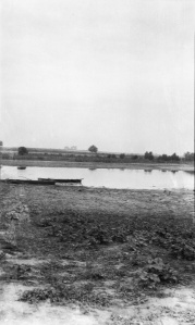
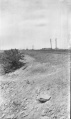
Caption: Hippert (HIPPARD?) mine on Freeburg road, freshly filled mine, water entering through cave
Credit: Illinois State Geological Survey
Library No.: M-1035
Caption: Gartside Mine, Murphysboro, sink in low land, pillar pulling
Credit: Illinois State Geological Survey
Library No.: M-1036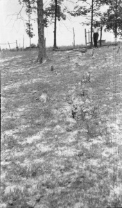
Caption: Superior Coal Mine No.2 Gillespie
Credit: Illinois State Geological Survey
Library No.: M-1042
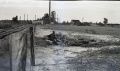
Caption: Subsidence fill, L and M track SE of Staunton--Consolidated No 6 mine
Credit: Illinois State Geological Survey
Library No.: M-1044
Caption: Subsidence fill, L and M track SE of Staunton--Consolidated No 6 mine
Credit: Illinois State Geological Survey
Library No.: M-1045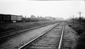
Caption: IL Central looking North from Madison shaft Divernon--sag in tracks and fill on rightt tracks
Credit: Illinois State Geological Survey
Library No.: M-1047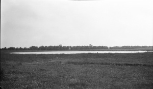
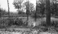
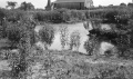
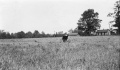
Caption: Pond North of Witt
Credit: Illinois State Geological Survey
Library No.: M-809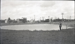
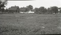
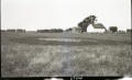
Caption: Pond caused by subsidence at Westville, Vermilion County, where 6 feet of coal was removed by room-and-pillar mining at a depth of 210 feet. Levels at surface show maximum depth of sag to by 4.7 feet.
Credit: Illinois State Geological Survey
Date: Pre-1914
Publication: Fig. 30 Cooperative Bulletin 17 – Subsidence in Illinois
Library No.: M-813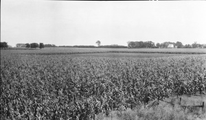
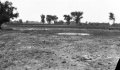
Caption: Open space south of Danville about 200 feet square in cornfield, indicating that area is not tilled because water stands over the sage in the spring.
Credit: Illinois State Geological Survey
Date: pre-1914
Publication: Fig. 31 Cooperative Bulletin 17 – Subsidence in Illinois
Library No.: M-821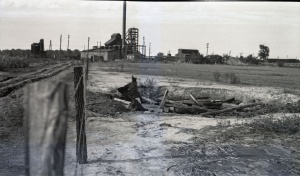
Caption: Pit hole filled with rubbish at the Electric mine near Danville
Credit: Illinois State Geological Survey
Date: Pre-1914
Publication: Fig. 35 Cooperative Bulletin 17 – Subsidence in Illinois
Library No.: M-822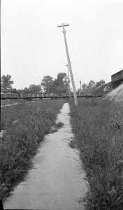
Caption: Broken sidewalk and telephone poles tipped toward a sag over Franklin Count Mine where and 8 foot coal is being removed at a depth of 450 feet.
Credit: Illinois State Geological Survey
Date: Pre-1914
Publication: Fig. 26 Cooperative Bulletin 17 – Subsidence in Illinois
Library No.: M-825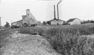
Caption: Swamp in a typical sag in Randolph County where a 6 foot coal is being mined at depth of 150 feet. The rooms are on 50 foot centers; pillars 18 feet.
Credit: Illinois State Geological Survey
Date: Pre-1914
Publication: Fig. 27 Cooperative Bulletin 17 – Subsidence in Illinois
Library No.: M-826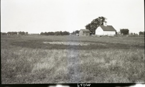
Caption: Subsidence Kelly No 5 Mine
(Mine Index:3740)
Credit: Illinois State Geological Survey
Date: Pre-1914
Library No.: M-929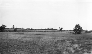
Credit: Illinois State Geological Survey
Library No.: M-932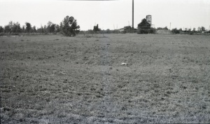
Caption: South of shaft, 3 feet deep
Credit: Illinois State Geological Survey
Library No.: M-933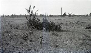
Caption: Kellyville No. 3 Near Electric mine Danville District. 8 foot diameter, 3 feet deep.
Credit: Illinois State Geological Survey
Library No.: M-934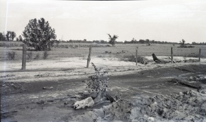
Caption: Ash filled road washed away.
Credit: Illinois State Geological Survey
Library No.: M-938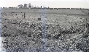
Credit: Illinois State Geological Survey
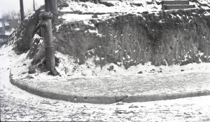
Caption: Break in curb and pavement in Decatur over the Manufacturers & Consumers Coal Co. Mine.
Credit: Illinois State Geological Survey
Date: Pre-1914
Library No.: M-947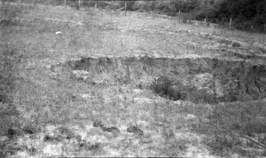
Caption: Caves on hillside
Credit: Illinois State Geological Survey
Library No.: M-952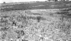
Caption: Subsidence along railroad tracks.
Credit: Illinois State Geological Survey
Library No.: M-959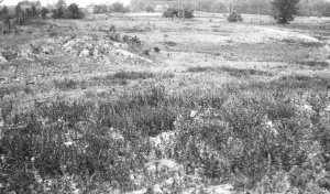
Caption: Subsidence in hilly area--mound (left foreground) over pillar.
Credit: Illinois State Geological Survey
Library No.: M-960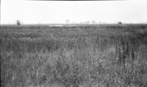
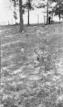
Caption: Sag foreground and background high grass over pillar
Credit: Illinois State Geological Survey
Library No.: M-962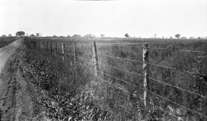
Caption: Sag--quarter mile long--fence shows sag of about 2 feet
Credit: Illinois State Geological Survey
Library No.: M-963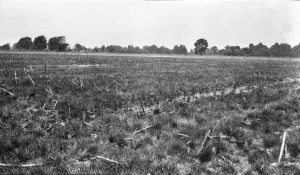
Caption: North-West of shaft, 800 feet across by 3 feet deep with some water
Credit: Illinois State Geological Survey
Library No.: M-965
Caption: Subsidence over two rooms east of Security shaft east of the ICRR south of Du Quoin
Credit: Illinois State Geological Survey
Library No.: M-966
Caption: Typical sag
Credit: Illinois State Geological Survey
Library No.: M-967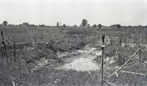
Caption: Surface breaks extending over a room in a mine near Harrisburg where the coal is 7 feet thick and 80 feet deep. The rooms are 24 feet wide and have 24 foot pillars
Credit: Illinois State Geological Survey
Date: Pre-1914
Publication: Fig. 13 Cooperative Bulletin 17 – Subsidence in Illinois
Library No.: M-968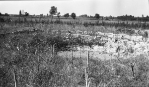
Caption: Breaks in field south of O'Gara No. 7
Credit: Illinois State Geological Survey
Library No.: M-969
Caption: Sag near Gartside Mine Murphysboro. Rig in sag.
Credit: Illinois State Geological Survey
Library No.: M-979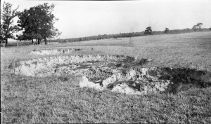
Caption: Surface breaks in a field near Carterville, 300 yards SW of Hafer Washed Coal Co. The shaft is 120 feet deep and a 7 foot bed of coal is being mined. The roof is slate and the overburden is clay; no quicksand has been noted. The breaks are about 20 feet in diameter and from a few feet to as much as 20 feet deep.
Credit: Illinois State Geological Survey
Date: Pre-1914
Publication: Fig. 12 Cooperative Bulletin 17 – Subsidence in Illinois
Library No.: M-991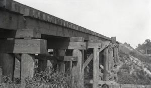
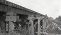
Caption: Repaired railroad trestle in Franklin County. One end subsided 18 inches more than the other, the total having been reported is about 4 feet.
Credit: Illinois State Geological Survey
Date: Pre-1914
Publication: Fig. 40 Cooperative Bulletin 17 – Subsidence in Illinois
Library No.: M-992![<b>Caption:</b> Barn of mining company lowered 4 feet at one end [right side]. It has been partially restored.<br><b>Credit:</b> Illinois State Geological Survey<br><b>Date:</b> Pre-1914<br><b>Library No.:</b> M-993](/images/thumb/f/fb/M-993_Old_Ben_8_mine_W_Frankfort_rt_end_4ft_lower.jpg/300px-M-993_Old_Ben_8_mine_W_Frankfort_rt_end_4ft_lower.jpg)
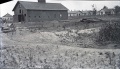
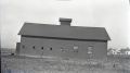
Caption: Barn of mining company lowered 4 feet at one end [right side]. It has been partially restored.
Credit: Illinois State Geological Survey
Date: Pre-1914
Library No.: M-993![<b>Caption:</b> Barn of mining company lowered 4 feet at one end [right side]. It has been partially restored.<br><b>Credit:</b> Illinois State Geological Survey<br><b>Date:</b> Pre-1914<br><b>Publication:</b> Fig. 47 Cooperative Bulletin 17 – Subsidence in Illinois<br><b>Library No.:</b> M-994](/images/thumb/a/ae/M-994_Old_Ben_8_mine_W_Frankfort_Coop_17_Fig_47_rt_end_4ft_lower.jpg/300px-M-994_Old_Ben_8_mine_W_Frankfort_Coop_17_Fig_47_rt_end_4ft_lower.jpg)
Caption: Barn of mining company lowered 4 feet at one end [right side]. It has been partially restored.
Credit: Illinois State Geological Survey
Date: Pre-1914
Publication: Fig. 47 Cooperative Bulletin 17 – Subsidence in Illinois
Library No.: M-994
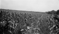
Caption: Drowned-out area of corn near Nokomis where the 8 foot coal bed is worked at a depth of about 625 feet.
Credit: Illinois State Geological Survey
Date: Pre-1914
Library No.: M-995
Caption: Drowned-out area of corn near Nokomis where the 8 foot coal bed is worked at a depth of about 625 feet.
Credit: Illinois State Geological Survey
Date: Pre-1914
Library No.: M-996
Caption: Drowned-out area of corn near Nokomis where the 8 foot coal bed is worked at a depth of about 625 feet.
Credit: Illinois State Geological Survey
Date: Pre-1914
Library No.: M-997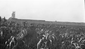
Caption: Drowned-out area of corn near Nokomis where the 8 foot coal bed is worked at a depth of about 625 feet.
Credit: Illinois State Geological Survey
Date: Pre-1914
Library No.: M-998


![<b>Caption:</b> Barn of mining company lowered 4 feet at one end [right side]. It has been partially restored.<br><b>Credit:</b> Illinois State Geological Survey<br><b>Date:</b> Pre-1914<br><b>Library No.:</b> M-993](/wiki/File:M-993_Old_Ben_8_mine_W_Frankfort_rt_end_4ft_lower.jpg)
![<b>Caption:</b> Barn of mining company lowered 4 feet at one end [right side]. It has been partially restored.<br><b>Credit:</b> Illinois State Geological Survey<br><b>Date:</b> Pre-1914<br><b>Publication:</b> Fig. 47 Cooperative Bulletin 17 – Subsidence in Illinois<br><b>Library No.:</b> M-994](/wiki/File:M-994_Old_Ben_8_mine_W_Frankfort_Coop_17_Fig_47_rt_end_4ft_lower.jpg)


Media in category "Mine Subsidence"
The following 51 files are in this category, out of 51 total.
 M-1000 Peabody 10 Nokomis sag corn field MI 194 8ft coal at 625ft.jpg 4,357 × 2,570; 1.32 MB
 M-1001 Peabody 10 Nokomis sag corn field MI 194 8ft coal at 625ft.jpg 4,381 × 2,567; 1.59 MB
 M-1003 NW Springfield IL Lincoln Park Coal Coop 17 Fig 44 5.75ft coal 200ft deep.jpg 2,500 × 1,456; 461 KB
 M-1004 NW Springfield IL Lincoln Park Coal see M-1003 and 1006.jpg 2,500 × 1,467; 637 KB
 M-1005 NW Springfield IL Lincoln Park Coal.jpg 2,500 × 1,467; 534 KB
 M-1006 NW Springfield IL Lincoln Park Coal see M-1004.jpg 2,500 × 1,481; 742 KB
 M-1007 Kelly No 5 Danville District Coop 17 Fig 42 6ft coal 200ft deep.jpg 2,500 × 1,484; 431 KB
 M-1008 Kelly No 5 Danville 6ft coal 200ft deep-ps.jpg 2,500 × 1,480; 545 KB
 M-1009 Kelly No 5 Danville District 6ft coal 200ft deep.jpg 2,500 × 1,461; 500 KB
 M-1010 Kelly No 5 Danville District 6ft coal 200ft deep.jpg 2,500 × 1,478; 573 KB
 M-1011 Kelly No 5 Danville District 6ft coal 200ft deep.jpg 1,454 × 2,500; 438 KB
 M-1033 Taylor Springs Peabody no 15 Plaster and foundation cracked.jpg 2,509 × 4,327; 1.21 MB
 M-1035 11 Hippert mine on Freeburg rd freshly filled mine water entering through cave.jpg 2,582 × 4,319; 1.09 MB
 M-1036 Gartside Mine Murphysboro sink low land pillar pulling.jpg 4,376 × 2,561; 1.39 MB
 M-1042 Superior Coal Mine no 2 Gillespie.jpg 2,568 × 4,378; 1.29 MB
 M-1044 sub fill L and M track SE of Staunton Consolidated no 6 mine.jpg 2,572 × 4,350; 1.09 MB
 M-1045 sub fill LandM track SE of Staunton Consolidated no 6 mine.jpg 2,584 × 4,338; 1.32 MB
 M-809 Pond N of Witt Peabody 14.jpg 4,375 × 2,550; 1.04 MB
 M-821 Coop 17 Fig 31 Dering Coal Co Danville District.jpg 4,388 × 2,577; 1.22 MB
 M-822 Copp 17 Fig 35 Pit s of Electric Mine Danville District see M-934.jpg 2,500 × 1,469; 579 KB
 M-825 Coop 17 fig 26 broken sidewalk tilted pole Old Ben 8 - 8ft coal at 450ft.jpg 2,544 × 4,340; 1.07 MB
 M-826 Coop 17 fig 27.jpg 2,500 × 1,471; 463 KB
 M-929 Subsidence Kelly No 5 Mine.jpg 4,408 × 2,666; 1.18 MB
 M-932 Kellyville No 3 near Electric mine Danville District.jpg 4,388 × 2,555; 1.38 MB
 M-933 Kellyville No 3 S of shalft 3ft deep Electric mine Danville District.jpg 2,500 × 1,477; 802 KB
 M-934 Kellyville No 3 near Electric mine Danville District 8ft dia 3ft deep.jpg 2,500 × 1,464; 719 KB
 M-939 Kellyville No 3 near Electric mine Danville District.jpg 2,500 × 1,465; 731 KB
 M-947 break in curb and pavement Decatur over M C CC.jpg 2,500 × 1,446; 545 KB
 M-952 Madison CC Dewaine IL caves on hill side.jpg 4,348 × 2,580; 1.1 MB
 M-959 Taylor No 1 Carterville Subsidence along RR tracks 1.jpg 4,344 × 2,547; 1.13 MB
 M-960 Taylor No 1 Carterville sub in hilly area-mound left foreground over pillar.jpg 2,500 × 1,467; 481 KB
 M-962 Sunfield mine Duquoin sag foreground and background high grass over pillar.jpg 4,376 × 2,586; 1.36 MB
 M-963 Majestic Mine-Duquoin sag quarter mile long fence shows sag of about 2ft.jpg 4,366 × 2,554; 1.28 MB
 M-965 Paradise Mine E of Duquoin NW of shaft 800ft across 3ft deep some wtr.jpg 4,344 × 2,539; 1.21 MB
 M-966 sink over two rooms E of Security shaft E of ICRR S of Duquoin.jpg 4,365 × 2,570; 1.48 MB
 M-967 Sunfield Mine typical Duquoin sag.jpg 4,355 × 2,541; 1.3 MB
 M-968 OGara CC no 7 Coop 17 Fig 13 7ft coal 80ft deep.jpg 2,500 × 1,457; 622 KB
 M-969 Breaks in field S of OGara Co No 7 Harrisburg.jpg 4,376 × 2,548; 1.39 MB
 M-979 Sag near Gartside Mine Murphysboro rig in sag.jpg 4,373 × 2,553; 973 KB
 M-991 Coop 17 fig 12.jpg 2,500 × 1,471; 575 KB
 M-992 Coop 17 Fig 40 trestle 1.5ft submine.jpg 2,500 × 1,460; 366 KB
 M-993 Old Ben 8 mine W Frankfort rt end 4ft lower.jpg 2,500 × 1,440; 509 KB
 M-994 Old Ben 8 mine W Frankfort Coop 17 Fig 47 rt end 4ft lower.jpg 2,500 × 1,397; 379 KB
 M-995 Peabody 10 Nokomis sag corn field MI 194 8ft coal at 625ft.jpg 4,365 × 2,537; 1.09 MB
 M-996 Peabody 10 Nokomis sag corn field MI 194 8ft coal at 625ft.jpg 4,385 × 2,553; 1.19 MB
 M-997 Peabody 10 Nokomis sag corn field MI 194 8ft coal at 625ft.jpg 4,373 × 2,547; 1.21 MB
 M-998 Peabody 10 Nokomis sag corn field MI 194 8ft coal at 625ft.jpg 4,391 × 2,536; 1.54 MB
 M-999 Peabody 10 Nokomis Coop 17 fig 32 sag corn field MI 194 8ft coal at 625ft.jpg 4,370 × 2,536; 1.14 MB
