Mine Index Number: 0064
| Company Name:
|
Hafer Washed Coal Company
|
| Mine Name:
|
Hafer No. 3 Mine
|
| Start Date:
|
1906
|
End Date:
|
March 1924
|
| Type of Mine:
|
Underground
|
| Total acres shown:
|
362
|
| Acres after map date:
|
|
General Area of mining acres shown:
|
|
|
|
Shaft, Slope, Drift or Tipple Location(s)
| Type
|
County
|
Township-Range
|
Section
|
Part Section
|
| Main shaft
|
Williamson
|
8S 1E
|
36
|
SW NW NE
|
| Air shaft
|
Williamson
|
8S 1E
|
36
|
NW SW NE
|
Geology
| Herrin
|
120
|
7.0
|
9.0
|
8.0
|
MRP
|
Geological Problems Reported
In the west and southwest part of the mine, the streams on the surface eroded down to the coal and sometimes into the coal itself. In this area, the mine was shallow and as soon as the coal was mined, the roof came down, filling the entries with the yellow sand and plastic clay deposited by the stream. The roof in the other areas of the mine was a light gray shale that slaked off readily; top coal was left to help support the roof. The source map noted rolls in the northwestern part of the mine. The floor clay became soft when wet, but did not tend to heave.
Production
| Company
|
Mine Name
|
Date
|
Production (tons)
|
|
|
|
|
|
| Total Production: 2,811,582
|
Production Notes
Coal Report production (if available)
Sources of Data
| Company
|
3-1924
|
1:1200
|
1:1200
|
Final
|
Annotated Bibliography (Data source - brief description of information)
| Coal Reports - Production, ownership, years of operation, depth, mining method.
|
| Directory of Illinois Coal Mines (Williamson County) - Mine names, mine index, ownership, years of operation.
|
| Mine notes (Williamson County) - Mine type, shaft location, seam, thickness, geologic problems.
|
| Company map, Old Ben Archive Collection - Shaft locations, mine outline, mining method, geologic problems.
|
Mine Notes
Mine Images
![[[:Hafer No. 3|Hafer No. 3]]](https://wikiimage.isgs.illinois.edu/ilmines/williamson/thumbnails/m0064_th.jpg) These files may not be true to scale and are not georgistered. These files may not be true to scale and are not georgistered.
|
Map Type:
|
Company
|
| Map ID:
|
il_0998
|
| Company:
|
Hafer Washed Coal Company
|
| Mine Name:
|
Hafer No. 3
|
| Caption:
|
|
| Map Date:
|
March 1924
|
| Map Status:
|
Final
|
| Image Credit:
|
|
| Note:
|
|
| More Info:
|
M0064.jpg
|
| Full Res Download:These files are true to scale and most are georegistered for gis software. These files may be a very large (>1GB) download!
|
https://wikiimage.isgs.illinois.edu/ilmines/williamson/m0064.zip
|
Photographs
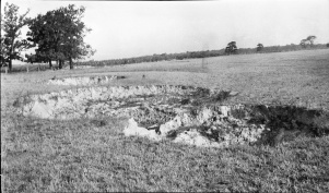
Caption: Surface breaks in a field near Carterville, 300 yards SW of Hafer Washed Coal Co. The shaft is 120 feet deep and a 7 foot bed of coal is being mined. The roof is slate and the overburden is clay; no quicksand has been noted. The breaks are about 20 feet in diameter and from a few feet to as much as 20 feet deep.
Credit: Illinois State Geological Survey
Date: Pre-1914
Publication: Fig. 12 Cooperative Bulletin 17 – Subsidence in Illinois
Library No.: M-991


![[[:Hafer No. 3|Hafer No. 3]]](https://wikiimage.isgs.illinois.edu/ilmines/williamson/thumbnails/m0064_th.jpg)
