3695: Difference between revisions
Alan.Myers (talk | contribs) No edit summary |
No edit summary |
||
| Line 3: | Line 3: | ||
|unlocated=No | |unlocated=No | ||
|shown_on_map=Yes | |shown_on_map=Yes | ||
|reason_nsm=The extent of production of the many small mines that operated on this property is not known, and a general area of mining has been drawn to indicate this uncertainty. | |||
|Mine-index=3695 | |Mine-index=3695 | ||
|Coal_co=Blackburn Coal Company | |Coal_co=Blackburn Coal Company | ||
|Mine Name Header=Blackburn Mine | |Mine Name Header=Blackburn Mine | ||
|mine_type=Underground | |mine_type=Underground | ||
|mined-out-area=None {{#info: Production indicates approximately 5 acres were mined. | |mined-out-area=None {{#info: Production indicates approximately 5 acres were mined.|note}} | ||
|county1=Vermilion | |county1=Vermilion | ||
|quad1=Danville Southwest | |quad1=Danville Southwest | ||
Revision as of 09:39, June 12, 2020
Mine Index Number: 3695
| Company Name: | Blackburn Coal Company | ||
|---|---|---|---|
| Mine Name: | Blackburn Mine | ||
| Start Date: | 1934 | End Date: | 1941 |
| Type of Mine: | Underground | ||
| Total acres shown: | None Production indicates approximately 5 acres were mined. | ||
| Acres after map date: | General Area of mining acres shown: | ||
|
The extent of production of the many small mines that operated on this property is not known, and a general area of mining has been drawn to indicate this uncertainty. | |||
Shaft, Slope, Drift or Tipple Location(s)
| Type | County | Township-Range | Section | Part Section |
|---|
| Main slope | Vermilion | 19N 11W | 18 | NW SW NE Other mines on this property were reported at SW SE NE, NW SE NE (2), SW NE NE, SW NE NE, SW NW NE, SE NW NE, NW SW NE, SW SW NE (2), NW SE NW and NE SW NW. See the note under production. |
Geology
| Thickness (ft) | |||||
|---|---|---|---|---|---|
| Seam | Depth (ft) | Min | Max | Ave | Mining Method |
| Danville | 4-5 | 6.0 | RP and Surface |
Geological Problems Reported
Production
| Company | Mine Name | Date | Production (tons) |
| Blackburn Coal Company lessor John Donaldson | Blackburn | 1934-1934 | 6,218 |
| Blackburn Coal Company | Blackburn | 1935-1937 | 18,465 |
| Donaldson-Fairhall Donaldson-Fairhall and at least the later Blackburn listings were not operating concerns, but a reporting composite of the leased Blackburn Coal Properties. There were at least 9 small operations reporting under this umbrella listing in 1938. Some of these later reported under their own names. | Blackburn | 1938-1939 | 3,081 |
| Blackburn Coal Company Donaldson-Fairhall and at least the later Blackburn listings were not operating concerns, but a reporting composite of the leased Blackburn Coal Properties. There were at least 9 small operations reporting under this umbrella listing in 1938. Some of these later reported under their own names. | Blackburn | 1940-1941 | 1,750 |
Production Notes
Coal Report production (if available)
Sources of Data
| Source Map | Map Date | Original Scale | Digitized Scale | Map Type |
| ISGS mine notes | Undated | (text only) | 1:24000 Point plotted onto 1:24,000 USGS topographic map and digitized. | Undated |
Annotated Bibliography (Data source - brief description of information)
| Coal Reports - Production, ownership, years of operation, mining methods. |
| Directory of Illinois Coal Mines (Vermilion County) - Mine names, mine index, ownership, years of operation. |
| Mine notes (Vermilion County) - Mine type, slope and tipple locations, seam, depth, thickness. |
Mine Notes
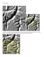
Mine Images
Photographs