Mine Index Number: 3695
| Company Name:
|
Blackburn Coal Company
|
| Mine Name:
|
Blackburn Mine
|
| Start Date:
|
1934
|
End Date:
|
1941
|
| Type of Mine:
|
Underground
|
| Total acres shown:
|
None
|
| Production Indicated Acres:
|
5
|
General Area of mining acres shown:
|
|
|
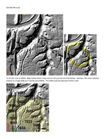
The extent of production of the many small mines that operated on this property is not known, and a general area of mining has been drawn to indicate this uncertainty.
|
Shaft, Slope, Drift or Tipple Location(s)
| Type
|
County
|
Township-Range
|
Section
|
Part Section
|
| Main slope
|
Vermilion
|
19N 11W
|
18
|
NW SW NE
|
| Mine
|
Vermilion
|
19N 11W
|
18
|
NE SW NW
|
| Mine
|
Vermilion
|
19N 11W
|
18
|
NW SE NW
|
| Mine
|
Vermilion
|
19N 11W
|
18
|
SW SW NE
|
| Mine
|
Vermilion
|
19N 11W
|
18
|
SE NW NE
|
| Mine
|
Vermilion
|
19N 11W
|
18
|
SW NW NE
|
| Mine
|
Vermilion
|
19N 11W
|
18
|
SW NE NE
|
| Mine
|
Vermilion
|
19N 11W
|
18
|
NW SE NE
|
| Mine
|
Vermilion
|
19N 11W
|
18
|
SW SE NE
|
Geology
| Danville
|
4-5
|
|
|
6.0
|
RP, Surface
|
Geological Problems Reported
Production
| Company
|
Mine Name
|
Date
|
Production (tons)
|
| Donaldson-Fairhall Donaldson-Fairhall and at least the later Blackburn listings were not operating concerns, but a reporting composite of the leased Blackburn Coal Properties. There were at least 9 small operations reporting under this umbrella listing in 1938. Some of these later reported under their own names.
|
Blackburn
|
1938-1939
|
3,081
|
|
|
| Blackburn Coal Company Donaldson-Fairhall and at least the later Blackburn listings were not operating concerns, but a reporting composite of the leased Blackburn Coal Properties. There were at least 9 small operations reporting under this umbrella listing in 1938. Some of these later reported under their own names.
|
Blackburn
|
1940-1941
|
1,750
|
|
|
Production Notes
Coal Report production (if available)
Sources of Data
| ISGS mine notes
|
Undated
|
(text only)
|
1:24000 Point plotted onto 1:24,000 USGS topographic map and digitized.
|
Undated
|
Annotated Bibliography (Data source - brief description of information)
| Coal Reports - Production, ownership, years of operation, mining methods.
|
| Directory of Illinois Coal Mines (Vermilion County) - Mine names, mine index, ownership, years of operation.
|
| Mine notes (Vermilion County) - Mine type, slope and tipple locations, seam, depth, thickness.
|
Mine Notes
Mine Images
Photographs