0163: Difference between revisions
Jack Brown (talk | contribs) No edit summary |
No edit summary |
||
| Line 1: | Line 1: | ||
{{Sidebar Info Query}} | {{Sidebar Info Query}} | ||
{{Header | {{Header | ||
|checked=1st Entry | |||
|unlocated=No | |unlocated=No | ||
|shown_on_map=Yes | |shown_on_map=Yes | ||
| Line 7: | Line 8: | ||
|Mine Name Header=Madison No. 12 Mine | |Mine Name Header=Madison No. 12 Mine | ||
|mine_type=Underground | |mine_type=Underground | ||
|mined-out-area= | |mined-out-area=757 | ||
|county1=Williamson | |county1=Williamson | ||
|quad1=De Soto | |quad1=De Soto | ||
|quad2=Herrin | |quad2=Herrin | ||
|year-start=1920 | |year-start=1920 | ||
|year-end=1931 | |year-end=April 1931 | ||
}} | }} | ||
==Shaft, Slope, Drift or Tipple Location(s)== | ==Shaft, Slope, Drift or Tipple Location(s)== | ||
| Line 93: | Line 94: | ||
{{Query-image}} | {{Query-image}} | ||
===Photographs=== | |||
{{Photo Query}} | |||
==Additional Notes== | |||
{{Editwithform}} | |||
{{Editwithform}} | {{Editwithform}} | ||
Revision as of 20:13, December 6, 2021
Mine Index Number: 0163
| Company Name: | Madison Coal Corporation | ||
|---|---|---|---|
| Mine Name: | Madison No. 12 Mine | ||
| Start Date: | 1920 | End Date: | April 1931 |
| Type of Mine: | Underground | ||
| Total acres shown: | 757 | ||
| Acres after map date: | General Area of mining acres shown: | ||
Shaft, Slope, Drift or Tipple Location(s)
| Type | County | Township-Range | Section | Part Section |
|---|
| Main shaft | Williamson | 8S 1E | 20 | NE SW SE |
| Air shaft | Williamson | 8S 1E | 20 | NE SW SE |
Geology
| Thickness (ft) | |||||
|---|---|---|---|---|---|
| Seam | Depth (ft) | Min | Max | Ave | Mining Method |
| Herrin | 100-104 | 6.5-8.0 | RPP |
Geological Problems Reported
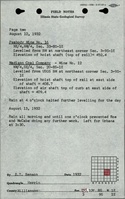
The source map showed bad top in SE SE 16-T8S-R1E. Pyrite was present in facings and small lenses.
Production
| Company | Mine Name | Date | Production (tons) |
| Madison Coal Corporation | Madison No. 12 | 1920-1931 | 5,705,151 |
Production Notes
Coal Report production (if available)
Sources of Data
| Source Map | Map Date | Original Scale | Digitized Scale | Map Type |
| Microfilm, document 353155 | 5-1931 | 1:2400 | 1:4469 | Final |
Annotated Bibliography (Data source - brief description of information)
| Coal Reports - Production, ownership, years of operation, seam, depth, thickness. |
| Directory of Illinois Coal Mines (Williamson County) - Mine names, mine index, ownership, years of operation. |
| ENR Document 85/01 - Mining method. |
| Mine notes (Williamson County) - Mine type, shaft location, mining method, depth, geologic problems. |
| Microfilm map, document 353155, reel 03142, frames 38-41 - Shaft locations, mine outline, mining method, geologic problems. |
Mine Notes
Mine Images
![[[:Madison No. 12|Madison No. 12]]](https://wikiimage.isgs.illinois.edu/ilmines/williamson/thumbnails/m0163_th.jpg)
Photographs
Additional Notes