4595: Difference between revisions
Kate.O'Brien (talk | contribs) (Created page with "{{Sidebar Info Query}} {{Header |checked=1st Entry |unlocated=No |shown_on_map=Yes |Mine-index=4595 |Coal_co=H. and V. Coal Company |Mine Name Header=H. and V. No. 1 Mine |min...") |
Alan.Myers (talk | contribs) No edit summary |
||
| (2 intermediate revisions by 2 users not shown) | |||
| Line 1: | Line 1: | ||
{{Sidebar Info Query}} | {{Sidebar Info Query}} | ||
{{Header | {{Header | ||
|checked= | |checked=Checked OK | ||
|unlocated=No | |unlocated=No | ||
|shown_on_map=Yes | |shown_on_map=Yes | ||
| Line 8: | Line 8: | ||
|Mine Name Header=H. and V. No. 1 Mine | |Mine Name Header=H. and V. No. 1 Mine | ||
|mine_type=Surface | |mine_type=Surface | ||
|mined-out-area=None | |mined-out-area=None | ||
|after_map=5 | |after_map=5 | ||
|county1=Saline | |county1=Saline | ||
| Line 14: | Line 14: | ||
|year-start=1959 | |year-start=1959 | ||
|year-end=February 1960 | |year-end=February 1960 | ||
|Latitude= | |Latitude=37.67004104 | ||
|Longitude= | |Longitude=-88.39523405 | ||
|Zoom=15 | |Zoom=15 | ||
}} | }} | ||
| Line 46: | Line 46: | ||
|Date=1959-1959 | |Date=1959-1959 | ||
|Production=not reported{{#info:1960 production includes No. 2 Mine (Mine Index 4596)|note}} | |Production=not reported{{#info:1960 production includes No. 2 Mine (Mine Index 4596)|note}} | ||
|Sum=No | |||
}} | }} | ||
{{Production | {{Production | ||
| Line 52: | Line 53: | ||
|Date=1959-1960 | |Date=1959-1960 | ||
|Production=37,538{{#info:Production probably all reported under second owner, H. and V.|note}} | |Production=37,538{{#info:Production probably all reported under second owner, H. and V.|note}} | ||
|Sum=No | |||
| | |||
}} | }} | ||
{{Production | {{Production | ||
|Production=37,538 | |Production=37,538 | ||
|Sum=Yes | |||
}} | }} | ||
===Production Notes=== | ===Production Notes=== | ||
Latest revision as of 15:26, April 15, 2022
Mine Index Number: 4595
| Company Name: | H. and V. Coal Company | ||
|---|---|---|---|
| Mine Name: | H. and V. No. 1 Mine | ||
| Start Date: | 1959 | End Date: | February 1960 |
| Type of Mine: | Surface | ||
| Total acres shown: | None | ||
| Acres after map date: | 5 | General Area of mining acres shown: | |
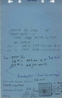
Shaft, Slope, Drift or Tipple Location(s)
| Type | County | Township-Range | Section | Part Section |
|---|
| Pit | Saline | 10S 7E | 11 | NE SW |
Geology
| Thickness (ft) | |||||
|---|---|---|---|---|---|
| Seam | Depth (ft) | Min | Max | Ave | Mining Method |
| Springfield | 5.0 | Surface |
Geological Problems Reported
Production
| Company | Mine Name | Date | Production (tons) |
| H. and M. Coal Company | H. and M. | 1959-1959 | not reported1960 production includes No. 2 Mine (Mine Index 4596) |
| H. and V. Coal Company | H. and V. No. 1 | 1959-1960 | 37,538Production probably all reported under second owner, H. and V. |
| Total Production: 37,538 | |||
Production Notes
Coal Report production (if available)
Sources of Data
| Source Map | Map Date | Original Scale | Digitized Scale | Map Type |
| Mine notes | 10-7-1981 | (text only) | 1:24000 | Secondary source |
| Digital ortho-photographic quadrangle | 2000 | 1:24000 | 1:24000 | Secondary source |
Annotated Bibliography (Data source - brief description of information)
| Coal Reports - Production, ownership, years of operation. |
| Directory of Illinois Coal Mines (Saline County) - Mine names, mine index, ownership, years of operation. |
| Mine notes (Saline County) - Mine type, mine location, seam, thickness. |
| USGS digital ortho-photographic Rudement Quadrangle - Mine location. |
Mine Notes
Mine Images
Photographs