0158: Difference between revisions
No edit summary |
No edit summary |
||
| (2 intermediate revisions by the same user not shown) | |||
| Line 8: | Line 8: | ||
|Mine Name Header=Energy No. 2 Mine | |Mine Name Header=Energy No. 2 Mine | ||
|mine_type=Underground | |mine_type=Underground | ||
|mined-out-area=630 | |mined-out-area=630 This area includes the Taylor No. 1 Mine (mine index [[0159]]). The boundaries between the mines could not be discerned. | ||
|indicated=No | |||
|county1=Williamson | |county1=Williamson | ||
|quad1=Herrin | |quad1=Herrin | ||
| Line 15: | Line 16: | ||
|Latitude=37.7843405908591 | |Latitude=37.7843405908591 | ||
|Longitude=-89.0296955930882 | |Longitude=-89.0296955930882 | ||
|Zoom=13 | |||
}} | }} | ||
==Shaft, Slope, Drift or Tipple Location(s)== | ==Shaft, Slope, Drift or Tipple Location(s)== | ||
| Line 55: | Line 57: | ||
|Date=1902-1904 | |Date=1902-1904 | ||
|Production=139,948 | |Production=139,948 | ||
|Sum=No | |||
}} | }} | ||
{{Production | {{Production | ||
| Line 61: | Line 64: | ||
|Date=1904-1905 | |Date=1904-1905 | ||
|Production=86,362 | |Production=86,362 | ||
|Sum=No | |||
}} | }} | ||
{{Production | {{Production | ||
| Line 67: | Line 71: | ||
|Date=1905-1906 | |Date=1905-1906 | ||
|Production=59,167 | |Production=59,167 | ||
|Sum=No | |||
}} | }} | ||
{{Production | {{Production | ||
| Line 73: | Line 78: | ||
|Date=1906-1909 | |Date=1906-1909 | ||
|Production=218,775 | |Production=218,775 | ||
|Sum=No | |||
}} | }} | ||
{{Production | {{Production | ||
| Line 79: | Line 85: | ||
|Date=1909-1914 | |Date=1909-1914 | ||
|Production=1,017,820 | |Production=1,017,820 | ||
|Sum=No | |||
}} | }} | ||
{{Production | {{Production | ||
| Line 85: | Line 92: | ||
|Date=1914-1919 | |Date=1914-1919 | ||
|Production=1,250,127 | |Production=1,250,127 | ||
|Sum=No | |||
}} | }} | ||
{{Production | {{Production | ||
| Line 91: | Line 99: | ||
|Date=1919-1923 | |Date=1919-1923 | ||
|Production=733,910 | |Production=733,910 | ||
|Sum=No | |||
}} | }} | ||
{{Production | {{Production | ||
| Line 97: | Line 106: | ||
|Date=1923-1923 | |Date=1923-1923 | ||
|Production=82,137 | |Production=82,137 | ||
|Sum=No | |||
}} | }} | ||
{{Production | {{Production | ||
|Production=-------- | |Production=-------- | ||
|Sum=No | |||
}} | }} | ||
{{Production | {{Production | ||
|Production=3,588,246 | |Production=3,588,246 | ||
|Sum=Yes | |||
}} | }} | ||
===Production Notes=== | ===Production Notes=== | ||
Latest revision as of 16:22, July 27, 2022
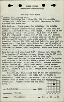
Mine Index Number: 0158
| Company Name: | Franklin County Coal Company | ||
|---|---|---|---|
| Mine Name: | Energy No. 2 Mine | ||
| Start Date: | 1902 | End Date: | November 1923 |
| Type of Mine: | Underground | ||
| Total acres shown: | 630 This area includes the Taylor No. 1 Mine (mine index 0159). The boundaries between the mines could not be discerned. | ||
| Acres after map date: | General Area of mining acres shown: | ||
Shaft, Slope, Drift or Tipple Location(s)
| Type | County | Township-Range | Section | Part Section |
|---|
| Main shaft | Williamson | 8S 2E | 31 | NE SE SW |
| Air shaft | Williamson | 8S 2E | 31 | NW SW NE |
Geology
| Thickness (ft) | |||||
|---|---|---|---|---|---|
| Seam | Depth (ft) | Min | Max | Ave | Mining Method |
| Herrin | 126 | 7.5 | 9.0 | 8.0 | MRP |
Geological Problems Reported
A fault was present, but apparently had no appreciable affect on mining. The roof consisted of 115 feet of massive gray sandy shale. Top coal was left to support the roof.
Production
| Company | Mine Name | Date | Production (tons) |
| Carterville Coal Company | Carterville No. 2 | 1902-1904 | 139,948 |
| Carterville Coal Company | Carterville B | 1904-1905 | 86,362 |
| Carterville Colliery Company | Carterville No. 2 | 1905-1906 | 59,167 |
| Carterville Mining Company | Carterville No. 2 | 1906-1909 | 218,775 |
| Taylor Coal Company | Taylor No. 2 | 1909-1914 | 1,017,820 |
| Taylor Mining Company | Taylor No. 2 | 1914-1919 | 1,250,127 |
| Taylor Coal Company | Energy No. 2 | 1919-1923 | 733,910 |
| Franklin County Coal Company | Energy No. 2 | 1923-1923 | 82,137 |
| Total Production: 3,588,246 | |||
Production Notes
Coal Report production (if available)
Sources of Data
| Source Map | Map Date | Original Scale | Digitized Scale | Map Type |
| Microfilm, document 353047 | 3-1924 | 1:2400 | 1:4965 | Final |
Annotated Bibliography (Data source - brief description of information)
| Coal Reports - Production, ownership, years of operation, mining method. |
| Directory of Illinois Coal Mines (Williamson County) - Mine names, mine index, ownership, years of operation. |
| Mine notes (Williamson County) - Mine type, shaft location, seam, depth, thickness, geologic problems. |
| Microfilm map, document 353047, reel 03141, frames 231 and 232 - Shaft locations, mine outline, mining method. |
Mine Notes
Mine Images
![[[:Taylor No. 2|Taylor No. 2]], [[:Taylor No. 1|Taylor No. 1]]](https://wikiimage.isgs.illinois.edu/ilmines/williamson/thumbnails/m0158_th.jpg)
Photographs