Category:Tilden-Quadrangle: Difference between revisions
Alan.Myers (talk | contribs) (Created page with "{{County-Page}}") |
Alan.Myers (talk | contribs) No edit summary |
||
| (One intermediate revision by the same user not shown) | |||
| Line 1: | Line 1: | ||
{{County- | __NOTOC__ | ||
==Mining in the Tilden Quadrangle== | |||
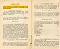
Mining began at the Wood Mine (mine index [[3190]]) in the southwestern corner of the Tilden Quadrangle | |||
before 1866 and ended in 1999 when the Marissa Mine (mine index 990) closed. The Herrin Coal was | |||
generally about 6 feet thick, and roof conditions were reasonably good. Most of the mines operated 20 | |||
years or more, with the Sparta Mine (mine index [[0701]]) running the longest (45 years). The coal was as | |||
deep as 200 feet, but with the advent of large equipment, surface mining took place between 1976 and | |||
1992 at the River King Pit No. 6 Mine (mine index [[0934]]). | |||
==Map and Directory PDF Download== | |||
[https://wikiimage.isgs.illinois.edu/ilmines/webfiles/topo-mines/Tilden.pdf Coal Mines In Illinois Tilden Quadrangle]</br> | |||
==Mines that Appear on the Tilden Quadrangle== | |||
{{#css: | |||
#mw-subcategories {display: none} | |||
#mw-pages {display: none} | |||
#mw-category-media {display: none} | |||
}} | |||
{{#ask:[[Category:Tilden-Quadrangle]] | |||
[[:+]] | |||
[[Unlocated::No]] | |||
|?combined = Coal Company, Mine Name | |||
|?County | |||
|format=datatables|limit=1500|link=all|sort=Mine Index|order=asc|headers=plain|mainlabel=Mine Index|searchlabel=... further results|class=sortable wikitable smwtable|sep=<br>|Default='''Mines for this quadrangle have not been entered into Ilmines-Wiki see download above for more information'''}} | |||
==Unlocated Mines== | |||
===Randolph County=== | |||
{{#ask:[[Category:Randolph-County]] | |||
[[:+]] | |||
[[Unlocated::Yes]] | |||
|?combined = Coal Company, Mine Name | |||
|?City | |||
|format=datatables|limit=1500|link=all|sort=Mine Index|order=asc|headers=plain|mainlabel=Mine Index|searchlabel=... further results|default=There are no known Unlocated mines in this county |class=sortable wikitable smwtable|sep=<br>}} | |||
===Washington County=== | |||
{{#ask:[[Category:Washington-County]] | |||
[[:+]] | |||
[[Unlocated::Yes]] | |||
|?combined = Coal Company, Mine Name | |||
|?City | |||
|format=datatables|limit=1500|link=all|sort=Mine Index|order=asc|headers=plain|mainlabel=Mine Index|searchlabel=... further results|default=There are no known Unlocated mines in this county |class=sortable wikitable smwtable|sep=<br>}} | |||
===St. Clair County=== | |||
{{#ask:[[Category:St. Clair-County]] | |||
[[:+]] | |||
[[Unlocated::Yes]] | |||
|?combined = Coal Company, Mine Name | |||
|?City | |||
|format=datatables|limit=1500|link=all|sort=Mine Index|order=asc|headers=plain|mainlabel=Mine Index|searchlabel=... further results|default=There are no known Unlocated mines in this county |class=sortable wikitable smwtable|sep=<br>}} | |||
{{DISPLAYTITLE:Tilden Quadrangle}} | |||
Latest revision as of 16:56, October 27, 2022
Mining in the Tilden Quadrangle
Mining began at the Wood Mine (mine index 3190) in the southwestern corner of the Tilden Quadrangle before 1866 and ended in 1999 when the Marissa Mine (mine index 990) closed. The Herrin Coal was generally about 6 feet thick, and roof conditions were reasonably good. Most of the mines operated 20 years or more, with the Sparta Mine (mine index 0701) running the longest (45 years). The coal was as deep as 200 feet, but with the advent of large equipment, surface mining took place between 1976 and 1992 at the River King Pit No. 6 Mine (mine index 0934).
Map and Directory PDF Download
Coal Mines In Illinois Tilden Quadrangle
Mines that Appear on the Tilden Quadrangle
Unlocated Mines
Randolph County
Washington County
St. Clair County
Pages in category "Tilden-Quadrangle"
The following 50 pages are in this category, out of 50 total.
1
M
- FileList:M0080 IL 392 01
- FileList:M0205 IL 122 01
- FileList:M0208a.tif
- FileList:M0654.tif
- FileList:M0701
- FileList:M0793 IL 134 01
- FileList:M0934.tif
- FileList:M0934a.tif
- FileList:M0934b.tif
- FileList:M0952 IL 788 01
- FileList:M0968 6 461N 2016.jpg
- FileList:M0990 MS 25 01 geo
- FileList:M0990.tif
- FileList:M1053 2019
- FileList:M1053 2020
- FileList:M1053 2024
- FileList:M3185.tif
- FileList:M3621 IL 115 03 geo
- FileList:M3625
- FileList:Marissa wpa
Media in category "Tilden-Quadrangle"
The following 24 files are in this category, out of 24 total.
 M0080 coalreport1900 p187.pdf 1,558 × 1,193; 351 KB
 M0080 coalreport1901 p239.pdf 1,308 × 1,168; 360 KB
 M0080 minenotes.pdf 737 × 1,183, 8 pages; 1.8 MB
 M0205 coalreport1903 p292.pdf 1,525 × 1,229; 249 KB
 M0205 minenotes.pdf 737 × 1,183, 13 pages; 2.8 MB
 M0208 minenotes.pdf 737 × 1,183, 25 pages; 5.79 MB
 M0654 minenotes.pdf 737 × 1,183, 21 pages; 5.01 MB
 M0701 minenotes.pdf 737 × 1,183, 49 pages; 4.44 MB
 M0793 coalreport1884 p577.pdf 1,577 × 1,275; 303 KB
 M0793 coalreport1899 p123.pdf 1,529 × 1,187; 332 KB
 M0793 minenotes.pdf 737 × 1,183, 2 pages; 409 KB
 M0934 minenotes.pdf 716 × 793, 55 pages; 5.7 MB
 M0952 minenotes.pdf 739 × 1,250, 68 pages; 7.64 MB
 M0968 minenotes.pdf 739 × 1,172, 39 pages; 9.16 MB
 M0990 minenotes.pdf 745 × 1,250, 59 pages; 19.98 MB
 M3184 minenotes.pdf 737 × 1,183, 5 pages; 913 KB
 M3185 minenotes.pdf 737 × 1,183, 10 pages; 2.27 MB
 M3621 minenotes.pdf 737 × 1,183, 15 pages; 7.04 MB
 M3622 coalreport1898 p201.pdf 1,591 × 1,170; 317 KB
 M3622 minenotes.pdf 737 × 1,183, 7 pages; 1.45 MB
 M3625 coalreport1884 p578.pdf 1,570 × 1,277; 309 KB
 M3625 coalreport1913 p228.pdf 793 × 1,187; 116 KB
 M3625 minenotes.pdf 737 × 1,183, 6 pages; 1.1 MB
 M3627 minenotes.pdf 737 × 1,183, 3 pages; 482 KB