2098: Difference between revisions
(Created page with "{{Sidebar Info Query}} {{Header |checked=1st Entry |unlocated=No |shown_on_map=Yes |Mine-index=2098 |Coal_co=Henry Herriford |Mine Name Header=Herriford Mine |mine_type=Underg...") |
No edit summary |
||
| (2 intermediate revisions by 2 users not shown) | |||
| Line 1: | Line 1: | ||
{{Sidebar Info Query}} | {{Sidebar Info Query}} | ||
{{Header | {{Header | ||
|checked= | |checked=Checked OK | ||
|unlocated=No | |unlocated=No | ||
|shown_on_map=Yes | |shown_on_map=Yes | ||
| Line 8: | Line 8: | ||
|Mine Name Header=Herriford Mine | |Mine Name Header=Herriford Mine | ||
|mine_type=Underground | |mine_type=Underground | ||
|mined-out-area= | |mined-out-area={{#info: The general area of mining is larger than indicated by reported production. Production indicates approximately 3 acres were mined.|note}} | ||
|indicated=No | |indicated=No | ||
|county1= | |gam=62 | ||
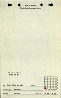
|county1=Fulton | |||
|quad1=Ipava | |quad1=Ipava | ||
|city1=Ipava | |||
|year-start=1929 | |year-start=1929 | ||
|year-end=1937 | |year-end=1937 | ||
|Latitude= | |Latitude=40.33569021 | ||
|Longitude= | |Longitude=-90.31248979 | ||
|Zoom=15 | |Zoom=15 | ||
}} | }} | ||
Latest revision as of 16:17, July 26, 2023
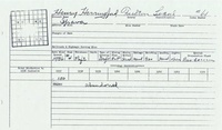
Mine Index Number: 2098
| Company Name: | Henry Herriford | ||
|---|---|---|---|
| Mine Name: | Herriford Mine | ||
| Start Date: | 1929 | End Date: | 1937 |
| Type of Mine: | Underground | ||
| Total acres shown: | The general area of mining is larger than indicated by reported production. Production indicates approximately 3 acres were mined. | ||
| Acres after map date: | General Area of mining acres shown: | 62 | |
Shaft, Slope, Drift or Tipple Location(s)
| Type | County | Township-Range | Section | Part Section |
|---|
| Main drift | Fulton | 4N 2E | 8 | SW SW SW |
Geology
| Thickness (ft) | |||||
|---|---|---|---|---|---|
| Seam | Depth (ft) | Min | Max | Ave | Mining Method |
| Springfield | 3.5 | RP |
Geological Problems Reported
Production
| Company | Mine Name | Date | Production (tons) |
| Henibud and Bronson | Henibud and Bronson | 1929-1930 Idle 1930 | 200 |
| Heniford and Leonard | Heniford and Leonard | 1931-1933 Production was not reported for mines producing less than 1,000 tons in 1932 and 1933. | 7,000 |
| Henry Herriford | Herriford | 1934-1937 | 1,925 |
| Total Production: 9,125 | |||
Production Notes
Coal Report production (if available)
Sources of Data
| Source Map | Map Date | Original Scale | Digitized Scale | Map Type |
| Federal Land Bank Report | 4-1934 | 1:124800 | 1:124800 | Secondary source |
Annotated Bibliography (Data source - brief description of information)
| Coal Reports - Production, ownership, years of operation. |
| Directory of Illinois Coal Mines (Fulton County) - Mine names, mine index, ownership, years of operation. |
| Mine notes (Fulton County) - Mine type, shaft location, seam, depth, thickness. |
| Mine Inspector's reports, courtesy of Joe Pelc, IDNR - Mine type, thickness, mining method. |
| Federal Land Bank Report (Fulton County) - Mine location. |
Mine Notes
Mine Images


Photographs