3663: Difference between revisions
No edit summary |
No edit summary |
||
| Line 1: | Line 1: | ||
{{Sidebar Info Query}} | {{Sidebar Info Query}} | ||
{{Header | {{Header | ||
|checked= | |checked=Checked OK | ||
|unlocated=No | |unlocated=No | ||
|shown_on_map=Yes | |shown_on_map=Yes | ||
| Line 100: | Line 100: | ||
{{Annotated bibliography | {{Annotated bibliography | ||
|bibliography=Directory of Illinois Coal Mines (Vermilion County) - Mine names, mine index, ownership, years of operation. | |bibliography=Directory of Illinois Coal Mines (Vermilion County) - Mine names, mine index, ownership, years of operation. | ||
}} | }} | ||
{{Annotated bibliography | {{Annotated bibliography | ||
Revision as of 13:50, September 11, 2022
Mine Index Number: 3663
| Company Name: | United States Fuel Company | ||
|---|---|---|---|
| Mine Name: | Kelly No. 3 Mine | ||
| Start Date: | 1896 | End Date: | 1921 |
| Type of Mine: | Underground | ||
| Total acres shown: | 1,152 | ||
| Acres after map date: | General Area of mining acres shown: | ||
Shaft, Slope, Drift or Tipple Location(s)
| Type | County | Township-Range | Section | Part Section |
|---|
| Main shaft | Vermilion | 18N 11W | 7 | NW SW NE No air shafts were shown in this portion of the Kelly mines complex. Interconnection with other Kelly mines underground may have provided air and escapeways to satisfy regulations of the times. |
Geology
| Thickness (ft) | |||||
|---|---|---|---|---|---|
| Seam | Depth (ft) | Min | Max | Ave | Mining Method |
| Herrin | 189-195 | 5.5-6.0 | RP |
Geological Problems Reported
Production
| Company | Mine Name | Date | Production (tons) |
| Kelly Coal Company | Kelly No. 3 | 1896-1897 | 221,197 |
| Kellyville Coal Company | Kelly No. 3 | 1897-1904 | 2,466,856 |
| Kelly Coal Company | Kelly No. 3 | 1904-1905 Abandoned 1905; re-opened 1911 | 273,592 |
| Bunsen Coal Company | Kelly No. 3 | 1911-1916 Abandoned 1905; re-opened 1911 | 1,625,128 |
| United States Fuel Company | Kelly No. 3 | 1916-1921 | 1,160,477 |
| Total Production: 5,747,250 | |||
Production Notes
Coal Report production (if available)
Sources of Data
| Source Map | Map Date | Original Scale | Digitized Scale | Map Type |
| ISGS map library, 4103.V4 i5.1-135 A final map is available at the Vermilion County Recorder’s Office (cabinet 03899, drawer 2). The map is too large to trace. | 7-1-1947 | 1:42240 | 1:42240 | Secondary source |
Annotated Bibliography (Data source - brief description of information)
| Coal Reports - Production, ownership, years of operation, mine type, mining method. |
| Directory of Illinois Coal Mines (Vermilion County) - Mine names, mine index, ownership, years of operation. |
| Mine notes (Vermilion County) - Mine type, shaft location, seam, depth, thickness. |
| ISGS map library, 4103.V4 i5.1-135, property map of U.S. Coal & Coke Company - Shaft locations, mine outline, mining method. |
Mine Notes
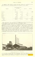
Mine Images

Photographs


